
Geospatial Solutions Market Size by Compnent, Technology, Application, End-User, Region – Revenue Pool Analysis, Margin Structure Assessment, Capital Flow Trends, Competitive Benchmarking & Forecast to 2032
Overview
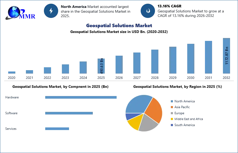
The Geospatial Solutions Market was valued at USD 493.63 Bn in 2025, and total Geospatial Solutions Market revenue is expected to grow at a CAGR of 13.16% and reach nearly USD 1172.87 Bn from 2026-2032. Growth driven by mapping, analytics and smart cities.
Geospatial solutions are a collection of tools and technologies that allow for the visualization, analysis, and collection of geospatial data. The Geospatial Solutions market growing rapidly driven by rising security threats globally, including terrorism, vandalism, and theft, prompting increased adoption of robust perimeter security solutions. Technological advancements such as AI-enabled analytics, IoT integration, and machine learning algorithms are enhancing the accuracy and responsiveness of PIDS, while stringent government regulations and industry standards are further propelling market expansion. Key components such as sensors, communication systems, and centralized control centers facilitate comprehensive perimeter security solutions, integrated with CCTV, access control, and alarm systems for enhanced situational awareness and response automation. Geospatial Solutions Market segmentation by component, deployment type, and vertical reflects diverse applications across critical infrastructure, defense, commercial, industrial, and residential sectors. Leading regions in the Geospatial Solutions Market such as North America, Europe, and Asia Pacific are witnessing significant growth, with emerging economies in Asia Pacific driving adoption through infrastructural developments and increasing security concerns.
To know about the Research Methodology :- Request Free Sample Report
Geospatial Solutions Market Dynamics:
Increasing Demand for Location-Based Services Driving Geospatial Solutions Market Growth
The increasing demand for location-based services, particularly in industries such as ride-sharing and food delivery, is driving the adoption of geospatial technology for real-time tracking and route optimization, enhancing user experience and operational efficiency which driving the growth of Geospatial Solutions Market. Advancements in satellite technology, exemplified by companies such as SpaceX and Planet Labs, are leading to higher-resolution imagery and improved data accuracy, benefiting applications in agriculture, environmental monitoring, and urban planning. The rising adoption of IoT devices embedded with location sensors is driving demand for geospatial solutions, particularly in smart city initiatives where IoT sensors are utilized for traffic monitoring, energy optimization, and public safety enhancements.
The growing applications of geospatial solutions in autonomous vehicles, disaster management, and infrastructure development are contributing to market growth. For instance, companies such as Waymo and Tesla rely on high-definition maps and real-time geospatial data for safe and efficient autonomous driving, while organizations such as FEMA and the Red Cross leverage GIS technology for disaster preparedness and response. Integration of geospatial solutions with AI and machine learning algorithms enhances analytical capabilities, while the emergence of 5G technology further supports innovative geospatial applications such as augmented reality navigation and real-time asset tracking. Moreover, regulatory initiatives mandating the use of geospatial data in various sectors and the increasing demand for precision agriculture practices are driving Geospatial Solutions Market Growth in the geospatial solutions industry.
Interoperability and Data Standardization Issues Hinders the Geospatial Solutions Market Growth
Data privacy concerns, exemplified by incidents such as Strava's inadvertent exposure of military personnel's location data, underscore the need for robust privacy regulations and data protection measures. Limited satellite coverage in certain regions hampers access to high-quality geospatial data, creating disparities in service provision and hindering applications like agriculture and disaster management. The high cost of acquiring and processing high-resolution imagery poses a significant barrier, especially for small businesses and local governments with budget constraints, limiting their ability to leverage geospatial technology effectively.
Interoperability issues among geospatial platforms and systems further complicate data integration and collaboration efforts, hindering the development of comprehensive solutions. Ethical and legal implications surrounding geospatial analysis, such as concerns about privacy infringements and biases in predictive policing, raise questions about accountability and transparency in decision-making processes. Environmental impacts stemming from the deployment of large satellite constellations, geopolitical tensions affecting data sharing and export controls, and the complexity of integrating geospatial solutions with existing legacy systems add layers of challenges to market growth. The shortage of skilled professionals in geospatial analysis and talent retention exacerbates these challenges, while negative public perceptions and trust issues surrounding geospatial technology underscore the importance of addressing ethical and privacy concerns to foster greater acceptance and utilization of geospatial solutions.
Geospatial Solutions Market Segment Analysis:
Based on technology, the Geospatial Solutions Market is segmented into GIS/geospatial analytics, remote sensing, GPS, and 3D scanning. Among these, GIS/geospatial analytics dominated the market due to its wide application in mapping, spatial data analysis, and decision-making across various sectors. Remote sensing and GPS technologies are also essential, particularly in agriculture, defense, and environmental monitoring. 3D scanning is gaining momentum for its role in urban planning, construction, and infrastructure modeling, offering high-precision visualization.
Based on end user, the market is segmented into utility, business, transportation, defense & intelligence, infrastructure development, natural resources, and others. Defense & intelligence led this segment owing to its heavy reliance on real-time geospatial data for surveillance, mission planning, and threat detection. Infrastructure development and utility sectors are rapidly adopting geospatial tools for asset tracking, planning, and maintenance. Transportation and natural resource sectors are leveraging these solutions for logistics optimization, land management, and sustainable resource utilization.
Geospatial Solutions Market Regional Insights:
North America Dominance in the Geospatial Solutions Market
North America dominated the Geospatial Solutions Market by the United States, holds a significant share due to the presence of major geospatial technology providers, robust infrastructure, and extensive adoption across industries like transportation, agriculture, and defense. Initiatives such as NASA's Earth Observation System and investments in autonomous vehicles drive market growth in this region. While Europe follows closely, driven by initiatives such as the European Space Agency's Copernicus program and stringent regulations promoting environmental conservation and urban planning. Countries like Germany and the United Kingdom are at the forefront of geospatial innovation, leveraging technologies like LiDAR and satellite imagery for applications such as precision agriculture and smart city development.
Asia Pacific Geospatial Solutions Market emerges as a rapidly growing market, driven by increasing investments in infrastructure development, urbanization, and digital transformation. Countries like China and India witness substantial adoption of geospatial solutions in sectors like construction, utilities, and transportation. Moreover, initiatives like China's BeiDou Navigation Satellite System and India's Smart Cities Mission contribute to market expansion in the region.
Recent Industry Developments (2025–2026)
| Exact Date | Company | Development | Impact |
|---|---|---|---|
| 03 March 2026 | Trimble Inc. | The company spearheaded the adoption of the ISO 15143-4 Worksite Topographical Data standard to enable seamless interoperability across mixed construction fleets. | This initiative reduces technology adoption barriers and standardizes data flow between different machinery brands and office software. |
| 26 February 2026 | BlackSky Technology Inc. | The company successfully commissioned its third Gen-3 satellite, delivering very-high-resolution imagery to commercial operations within 24 hours of launch. | The deployment significantly expands constellation capacity, targeting $145 million in revenue for 2026 through international demand. |
| 28 November 2025 | Planet Labs PBC | Planet successfully launched its AI-enabled, high-resolution Pelican-5 and Pelican-6 satellites alongside 36 SuperDoves on a SpaceX mission. | These satellites feature onboard edge computing using NVIDIA’s Jetson platform to provide near-instant geospatial insights to customers. |
| 30 September 2025 | Planet Labs PBC | The company established a new high-tech satellite manufacturing facility in Berlin, Germany, to double its production capacity for Pelican satellites. | This expansion strengthens European technological sovereignty and addresses the growing regional demand for persistent Earth observation data. |
| 12 June 2025 | Hexagon AB | Hexagon entered into a definitive agreement to acquire Aero Photo Europe Investigation (APEI), a specialist in aerial mapping and elevation models. | The acquisition bolsters the Hexagon Content Program and enhances the company’s ability to serve government programs in Europe and Africa. |
| 23 April 2025 | TomTom International B.V. | TomTom was selected by smart, the electric auto brand, to provide full-stack navigation and EV services for its global vehicle lineup. | This partnership integrates real-time traffic data and ADAS maps, enhancing the competitive positioning of TomTom in the connected EV market. |
Scope of Global Geospatial Solutions Market: Inquire before buying
| Geospatial Solutions Market | |||
|---|---|---|---|
| Report Coverage | Details | ||
| Base Year: | 2025 | Forecast Period: | 2026-2032 |
| Historical Data: | 2020 to 2025 | Market Size in 2025: | 493.63 USD Bn. |
| Forecast Period 2026-2032 CAGR: | 13.16% | Market Size in 2032: | 1172.87 USD Bn. |
| Segments Covered: | by Compnent | Hardware Software Services |
|
| by Technology | GIS/Geospatial Analytics Remote Sensing GPS 3D Scanning |
||
| by Application | Surveying & Mapping Geovisualisation Planning & Analysis Land Management Others |
||
| by End-User | Utility Business Transportation Defense & Intelligence Infrastructure Development Natural Resources Others |
||
Global Geospatial Solutions Market, by Region
North America (United States, Canada and Mexico)
Europe (UK, France, Germany, Italy, Spain, Sweden, Austria and Rest of Europe)
Asia Pacific (China, South Korea, Japan, India, Australia, Indonesia, Malaysia, Vietnam, Taiwan, Bangladesh, Pakistan and Rest of APAC)
Middle East and Africa (South Africa, GCC, Egypt, Nigeria and Rest of ME&A)
South America (Brazil, Argentina Rest of South America)
Key Players / Competitors Profiles Covered in Brief in Global Geospatial Solutions Market Report in Strategic Perspective:
- Esri
- Pitney Bowes
- Bentley Systems
- Apple
- Oracle
- Microsoft
- Amazon
- IBM
- HERE Technologies
- Hexagon AB
- Atkins PLC
- TomTom International B.V.
- SAP
- Topcon Corporation
- Baidu
- China Geo-Engineering Corporation (CGC)
- RMSI
- Trimble Inc.
- Maxar Technologies
- Fugro
- Planet Labs PBC
- BlackSky Technology Inc.
- L3Harris Technologies
- Garmin Ltd.
- Autodesk, Inc.