
Geospatial Imagery Analytics Market Size – Industry Structure Evaluation, Demand Drivers Analysis, Regional Growth Analysis and Identification, Competitive Positioning Review & Global Market Size Forecast to 2032
Overview
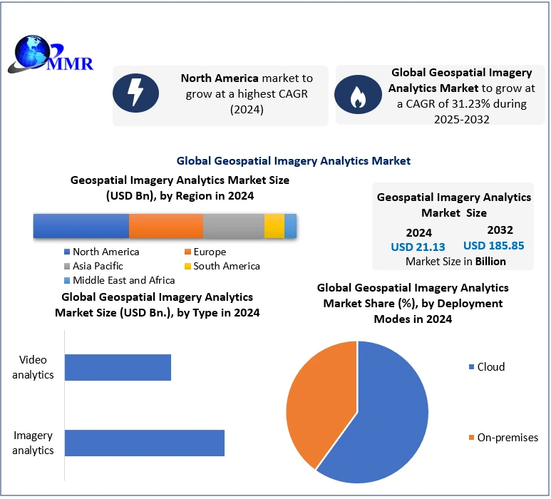
Global Geospatial Imagery Analytics Market size was valued at USD 21.13 Bn in 2024, and the total Geospatial Imagery Analytics Market revenue is expected to grow at a CAGR of 31.23% from 2025 to 2032, reaching nearly USD 185.85 Bn.
Geospatial Imagery Analytics is the process of examination and interpretation of satellite or aerial images to extract valuable insights about the Earth's surface, enabling detailed spatial analysis and decision-making across various industries.
 To know about the Research Methodology:- Request Free Sample Report
Geospatial Imagery Analytics Market is expected a significant growth due to the rising demand for location-based insights across various industries such as agriculture, defense, urban planning, and environmental monitoring. Factors driving this growth include technological advancements in remote sensing, the proliferation of drones equipped with high-resolution cameras, and the integration of Artificial Intelligence (AI) and Machine Learning (ML) algorithms for automated analysis of vast amounts of geospatial data. Companies like Maxar Technologies have made recent strides in the market by leveraging advanced analytics and machine learning techniques to provide high-resolution satellite imagery and analytics solutions for defense and intelligence applications. Maxar's use of cloud-based platforms and AI-driven analytics has enabled quicker and more accurate extraction of insights from geospatial data, catering to the increasing demand for real-time, actionable intelligence. Geospatial Imagery Analytics Market key players such as Google Earth, Esri, and Hexagon AB have also been actively involved in advancing geospatial imagery analytics, enhancing their offerings with improved visualization tools, data integration capabilities, and user-friendly interfaces to meet the evolving needs of diverse industries and governmental agencies, further driving the Geospatial Imagery Analytics Market growth.
Geospatial Imagery Analytics Market Dynamics:
Market Growth Driven by High-Resolution Drone Proliferation Revolutionizing Real-Time Aerial Imagery
Advancements in satellite imaging technology driving the growth of Geospatial Imagery Analytics market as Maxar's WorldView Legion satellites, mark a pivotal driver in the growth of the Geospatial Imagery Analytics. These innovations yield higher resolution and increased revisits, revolutionizing geospatial data accuracy and currency. This enhancement facilitates a spectrum of applications, from precise infrastructure monitoring to revolutionizing precision agriculture techniques. The improved resolution empowers detailed analysis and decision-making, aiding sectors such as disaster response, wildlife conservation, and construction site monitoring. The data's timeliness and granularity bolster actionable insights, transforming traditional practices across various industries.
The integration of high-resolution camera-equipped drones from industry leaders such as DJI and Parrot increases growth of Geospatial Imagery Analytics market. These drones furnish real-time aerial imagery, expediting data acquisition across sectors such as disaster management, wildlife conservation, and construction monitoring. This technology shift accelerates decision-making processes, harnessing near-instant geospatial data for critical applications. These advancements represent a paradigm shift in decision-making dynamics, fostering smarter, real-time responses in scenarios requiring rapid interventions or meticulous planning. The integration of AI algorithms by companies such as Orbital Insight serves as a catalyst for growth in this market. These algorithms enable the analysis of vast geospatial datasets, yielding actionable insights for financial markets, retail trend tracking, and global commodity flow monitoring. This application showcases the transformative potential of AI-driven analytics in harnessing the power of geospatial imagery for precise and data-driven decision-making across industries. The convergence of these technologies and their application across diverse sectors underscores the pivotal role of geospatial analytics in shaping industries and societal advancements worldwide.
Fluctuating Stance on Cryptocurrency Legality Hinders the Geospatial Imagery Analytics Market Growth
Challenges related to data privacy and security hinders the growth of Geospatial Imagery Analytics Market as Google Earth's privacy controversies stemming from high-resolution images, have prompted stringent regulations and limited data accessibility. The considerable expenses tied to acquiring high-resolution geospatial imagery, such as those offered by companies such as Maxar Technologies, create accessibility issues, especially for smaller enterprises and emerging economies. This financial barrier impedes their capacity to embrace sophisticated analytical tools, curtailing their competitive edge in utilizing geospatial insights for informed decision-making. Disparities in satellite coverage and geopolitical restrictions in certain regions create obstacles for comprehensive data collection. This limitation adversely impacts critical applications such as disaster response and environmental monitoring in remote areas, constraining the efficacy of geospatial analytics. Despite technological advancements, the interpretation of geospatial data demands specialized skills, limiting broader adoption. Complex analyses, such as those required for climate change studies or ecological monitoring using satellite imagery, necessitate expertise, thus hampering widespread understanding and application.
Governmental regulations and restrictions on satellite imagery usage, especially in sensitive or conflict-ridden zones, present challenges for companies like DigitalGlobe, affecting service availability. Integrating geospatial analytics into existing workflows, especially in domains like precision agriculture, requires overcoming complexities related to data integration from diverse sources like drones and satellites, necessitating specialized software and expertise. Ethical considerations in utilizing geospatial data for sensitive purposes, such as surveillance or military applications, pose ongoing challenges in maintaining a balance between innovation and ethical use. Addressing challenges related to data quality and reliability, such as cloud cover affecting satellite images or inaccuracies in terrain mapping, remains crucial for ensuring dependable decision-making across industries. The environmental impact of satellite operations raises concerns, impacting sustainability goals despite the benefits of geospatial analytics. The lack of standardized formats and interoperability between different geospatial data sources impedes seamless integration and analysis, highlighting the necessity of achieving uniform standards to unlock the full potential of geospatial imagery analytics.
Geospatial Imagery Analytics Market Segment Analysis:
Based on Type, Imagery analytics Segment dominated the Geospatial Imagery Analytics Market in 2024 and is expected to maintain its dominance over the forecast period. Imagery analytics Primarily focuses on static visual data extracted from satellite or aerial imagery. It finds extensive application across various sectors such as agriculture for crop monitoring, urban planning for infrastructure development, and defense for intelligence gathering. Its adoption has been substantial due to the historical significance of satellite imagery and its widespread availability. Video Analytics deals with dynamic data from real-time video feeds captured by drones or surveillance cameras. It excels in applications requiring continuous monitoring and rapid response, such as disaster management, traffic monitoring in smart cities, and security surveillance. Its adoption, though growing, faces challenges due to technological complexities and the need for real-time processing capabilities. While Imagery Analytics boasts a broader adoption base, Video Analytics offers agility and responsiveness for time-sensitive applications.
Based on Collection Medium, Geographic Information System (GIS) dominated the Geospatial Imagery Analytics Market with largest share in 2024. It is a software-based system, provides a robust platform for data visualization, analysis, and interpretation. Its applications span across various domains, including urban planning, environmental monitoring, and infrastructure management. Satellites remain the backbone of geospatial data collection, offering global coverage for applications like agriculture, defense, and disaster response due to their extensive historical data archives. UAVs, offering flexibility and high-resolution imagery, find application in precision agriculture, construction site monitoring, and rapid response scenarios, such as disaster management. Other emerging collection mediums, such as LiDAR or hyperspectral imaging, show potential in specialized applications like forestry, geological surveys, and archaeological studies. While Satellites dominate due to their wide coverage, UAVs and GIS offer agility and detail, catering to specific, high-precision applications, thereby diversifying the collection medium landscape in the Geospatial Imagery Analytics Market.
Geospatial Imagery Analytics Market Regional Insights:
North America Dominance in the Geospatial Imagery Analytics Market
North America dominated the Geospatial Imagery Analytics Market in 2023 as it emerges as a prominent production hub led by key players such as Maxar Technologies and Esri. Its technological prowess enables cutting-edge solutions and high-resolution satellite imagery fulfilling to defense, agriculture, and urban planning. Innovations in geospatial technologies continue to drive the region's advancements.
Asia-Pacific is an emerging region in Geospatial Imagery Analytics Market particularly China, India, and Japan, represents a robust consumer base leveraging geospatial analytics for smart city development, precision agriculture, and disaster management. The import-export scenario depicts North America exporting advanced tools and satellite data while Asia-Pacific imports technologies, bolstering its analytic capabilities. Europe, with players such as Airbus Defense and Space, contributes significantly, serving as a hub for technological advancements in the geospatial imagery analytics landscape.
Geospatial Imagery Analytics Market Scope: Inquire before buying
| Global Geospatial Imagery Analytics Market | |||
|---|---|---|---|
| Report Coverage | Details | ||
| Base Year: | 2024 | Forecast Period: | 2025-2032 |
| Historical Data: | 2019 to 2024 | Market Size in 2024: | USD 21.13 Bn. |
| Forecast Period 2025 to 2032 CAGR: | 31.23% | Market Size in 2032: | USD 185.85 Bn. |
| Segments Covered: | by Type | Imagery analytics Video analytics |
|
| by Deployment Modes | Cloud On-premises |
||
| by Cllection Medium | Geographic Information System (GIS) Satellites Unmanned Aerial Vehicles (UAVs) Others |
||
| by Vertical | Healthcare Government Defense and Security Environment Monitoring Engineering and Construction Agriculture Energy and Utilities Others |
||
| by Technology | GPS Geographic Information System (GIS) Remote Sensing Image Processing 3D Visualization Others |
||
Geospatial Imagery Analytics Market, by Region
North America (United States, Canada, and Mexico)
Europe (UK, France, Germany, Italy, Spain, Sweden, Austria and Rest of Europe)
Asia Pacific (China, South Korea, Japan, India, Australia, Indonesia, Malaysia, Vietnam, Taiwan, Bangladesh, Pakistan and Rest of APAC)
Middle East and Africa (South Africa, GCC, Egypt, Nigeria and Rest of ME&A)
South America (Brazil, Argentina Rest of South America)
Geospatial Imagery Analytics Market Key Players:
Major Contributors in the Geospatial Imagery Analytics Industry in North America:
1. Maxar Technologies, Westminster, Colorado, USA
2. Esri, Redlands, California, USA
3. Trimble, Sunnyvale, California, USA
4. DigitalGlobe Westminster, Colorado, USA
5. Harris Geospatial Solutions, Broomfield, Colorado, USA
6. Google, Mountain View, California, USA
7. Orbital Insight, Mountain View, California, USA
8. Planet Labs, San Francisco, California, USA
9. BlackSky, Herndon, Virginia, USA
10. SparkGeo, Toronto, Ontario, Canada
11. Teledyne Technologies, Thousand Oaks, California, USA
12. L3Harris Geospatial, Boulder, Colorado, USA
13. Intermap Technologies, Englewood, Colorado, USA
14. Satellogic, Buenos Aires, Argentina
15. UrtheCast, Vancouver, British Columbia, Canada
16. MDA, Brampton, Ontario, Canada
17. Terra Bella, Mountain View, California, USA
18. Sparkgeo, Victoria, British Columbia, Canada
Leading players in the Europe Geospatial Imagery Analytics Market:
1. GAF AG, Munich, Germany
2. Telespazio, Rome, Italy
3. CGG, Paris, France
4. Airbus Defence and Space, Toulouse, France
5. Hexagon AB, Stockholm, Sweden
6. Fugro, Leidschendam, Netherlands
Key players driving the Asia-Pacific Geospatial Imagery Analytics Market:
1. SI Imaging Services, Daejeon, South Korea
2. Satrec Initiative, Daejeon, South Korea
3. Harris Geospatial Solutions Asia Pacific, Melbourne, Australia
4. Satlab Geosolutions, New Delhi, India
5. Remote Sensing Technology Center of Japan (RESTEC), Tokyo, Japan
6. Japan Space Imaging Corporation, Tokyo, Japan
7. Skylab Analytics, Bengaluru, India
FAQs:
1] What Major Key players in the Global Geospatial Imagery Analytics Market report?
Ans. The Major Key players covered in the Geospatial Imagery Analytics Market report are Maxar Technologies, Westminster, Colorado, USA, Esri, Redlands, California, USA, Trimble, Sunnyvale, California, USA, Digital Globe Westminster, Colorado, USA
2] Which region is expected to hold the highest share in the Global Geospatial Imagery Analytics Market?
Ans. North America region is expected to hold the highest share in the Geospatial Imagery Analytics Market.
3] What is the market size of the Global Geospatial Imagery Analytics Market by 2032?
Ans. The market size of the Geospatial Imagery Analytics Market by 2032 is expected to reach USD 185.85 Bn.
4] What is the forecast period for the Global Geospatial Imagery Analytics Market?
Ans. The forecast period for the Geospatial Imagery Analytics Market is 2025-2032.
5] What was the market size of the Global Geospatial Imagery Analytics Market in 2024?
Ans. The market size of the Market in 2024 was valued at USD 21.13 Bn.