
Remote Sensing Technology Market Size by Technology, Application, Platform and Region – Segment-Level Market Assessment, Growth Opportunity Analysis, Competitive Mapping & Forecast to 2034
Overview
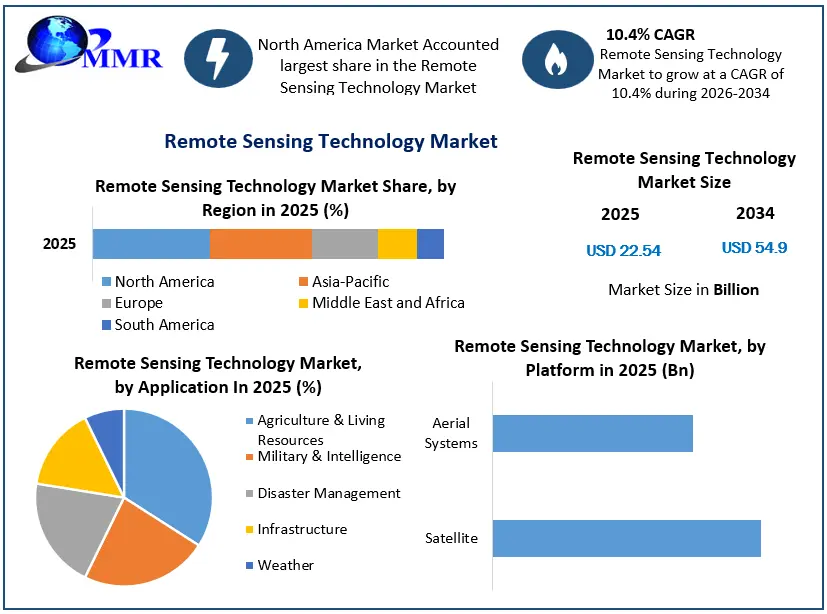
Remote Sensing Technology Market size was valued at US$ 22.54 Bn. in 2025 and expected to reach US$ 54.9 Bn. by 2034 at a CAGR of 10.4 % during the forecast period.
The global Remote Sensing Technology market report is a comprehensive analysis of the industry, market, and key players. The report has covered the market by demand and supply-side by segments. The global Remote Sensing Technology report also provides trends by market segments, technology, and investment with a competitive landscape.
Remote Sensing Technology Market Size, Growth & Share Analysis
To know about the Research Methodology :- Request Free Sample Report
Remote Sensing Technology Market Overview :
Remote sensing is the art of gathering information about an object or feature without directly contacting it. People use remote sensing in their daily lives by using their eyes, ears, and sense of smell. Variations in sound wave distributions (e.g., sonar), variations in force distributions (e.g., gravity meter), and variations in electromagnetic energy distributions (e.g., eye) are all examples of data that can be collected. These data are acquired remotely via multiple sensors.
Thus, remote sensing allows enormous areas to be observed at finer spatial and temporal frequencies. Moreover, watershed research, hydrological states, and fluxes simulation, hydrological modeling, disaster management services such as flood and drought warning, and damage assessment in the event of natural calamities are just a few of the uses.
Remote Sensing Technology Market Dynamics:
Remote sensing technology is used to collect data and analyze the physical features of the earth's surface. It relies on reflected and emitted light from planes and satellites rather than physical touch with the surface under investigation.
The growing number of earth observation programs undertaken by various space organizations are driving the market. For instance, in 2021, Earth Observation Satellites (EOS) like the Himawari-8 satellite from Japan Aerospace Exploration Agency (JAXA), NASA’s Suomi-NPP satellite, and the Sentinel-2 satellite by the European Space Agency (ESA) captured high-quality satellite images of Australian bushfires and Amazon forests fire.
The growing use of smart city initiatives is paving the path for market expansion. Zoning and urban planning, infrastructure modeling, and security and law enforcement planning are all aided by the technology. Several countries are focusing on infrastructure development and spending extensively on smart city projects. Over the forecast period, this is projected to fuel market expansion. Market participants must manufacture components and encrypt data content by regulatory requirements. This restricts a manufacturer's ability to grow in the market. However, the rising demand for autonomous vehicles, which include the technology into their sensing systems, is creating chances for the remote sensing technology market to grow over the forecast period. The market is likely to highlight unexplored market potential as well as increased user awareness.
Global Remote Sensing Technology Market Segment Analysis :
Based on the technology, the remote sensing technology market is bifurcated into active remote sensing and passive remote sensing. In 2025, the passive remote sensing sector had the biggest market share of 57.42 %. Solar energy is used as the source of EMR in the majority of remote sensing devices. Sensors onboard airborne or spaceborne platforms record the solar energy reflected by the objects at certain wavelength bands. Because the technology produces high-quality satellite images, it is frequently employed for a variety of earth observation activities.
Recent Launch by China:
In March 2021, China planned to launch LiDAR (light detection and ranging) system-based new satellite to monitor CO2 levels in the atmosphere. Since 2021, for CO2 monitoring and research China has launched three satellites into orbit, all of which are equipped with passive optical remote sensing technology.
During the forecast timeline, the active remote sensing segment is expected to grow at a CAGR of about 6.04 %. Energy is generated and delivered from the remote sensing platform to the targets in the case of active remote sensing. Sensors onboard the remote sensing platform record the energy reflected back from the objects. Active microwave remote sensing is used for the majority of microwave remote sensing. Forest structure, ice, and sea surface topography, among other things, are all measured using active remote sensing technology.
Passive remote sensing is comparable to taking a photo with a regular camera, but active remote sensing is comparable to taking a photo with a camera that includes a built-in flash.
Passive Remote Sensing Devices:
The spectrometer recognizes and analyzes spectral bands in passive remote sensing devices.
The power of radiation emitted by an object in specific band ranges is determined by a radiometer (visible, IR, microwave).
The power of radiation is measured using a spectroradiometer in many band ranges.
The most accurate sort of passive sensor utilized in remote sensing is employed in hyperspectral radiometers. It distinguishes hundreds of ultimately small spectral bands within the visible, NIR, and MIR ranges due to its extraordinarily high resolution.
To reproduce a picture, an imaging radiometer scans an item or a surface.
Vertically, the sounder detects air conditions.
Remote Sensing Technology Market Regional Insights:
In 2025, North America had the largest market share of 38.10 %. The presence of significant market players such as Lockheed Martin Corporation, Esri, and General Dynamics Mission Systems, Inc., among others, account for this share. During the projected period, the adoption of remote sensing technology in precision farming applications is expected to drive market growth. Water resource managers can use the technology to reduce the impact of dry spells and droughts, as well as match agricultural irrigation needs.
Remote Sensing Technology Market Recent Industry Developments
| Date | Company | Development | Impact |
|---|---|---|---|
| 14 January 2025 | Planet Labs PBC | Planet Labs successfully launched its Pelican-2 high-resolution remote sensing satellite equipped with an NVIDIA GPU processor for edge AI analytics. | The deployment reduces satellite-to-satellite latency and delivers critical geospatial observation data to defense and commercial clients in minutes rather than hours. |
| 30 January 2025 | Planet Labs PBC | Planet Labs secured a multi-year $230 million strategic expansion agreement with a major Asia-Pacific commercial partner for dedicated satellite capacity. | The contract accelerates deployment of the next-generation Pelican constellation, greatly scaling high-resolution commercial Earth observation coverage worldwide. |
| 29 April 2025 | Airbus Defence and Space | Airbus, in partnership with ESA, launched the Biomass radar satellite mission featuring a specialized P-band synthetic aperture radar (SAR) payload. | The mission generates global 3D maps of forest biomass through dense foliage, significantly upgrading global climate modeling and forest carbon tracking capabilities. |
| 30 July 2025 | NASA / ISRO (Joint Mission) | NASA and ISRO launched the $1.5 billion NISAR Earth-imaging satellite, utilizing dual-frequency (L-band and S-band) SAR. | It delivers global land and ice deformation tracking with centimeter-level precision every 12 days, transforming disaster management and climate hazard response. |
Remote Sensing Technology Use in Precision Agriculture:
During the last couple of decades, the use of remote sensing technologies for PA has exploded. Crop monitoring, irrigation control, nutrient application, disease & pest management, and yield prediction have all benefited from the unprecedented availability of high-resolution (spatial, spectral, and temporal) satellite pictures. PA technologies based on remote sensing, including Green Seeker's variable fertilizer rate application system and Crop Circle, have already been adopted in commercial agriculture.
During the projection period, Asia Pacific is expected to grow at a significant CAGR of over 12%. This can be attributed to the growing use of earth observation for infrastructure building purposes. China, Japan, Australia, and India are among the most attractive markets for remote sensing technology vendors in the region. Government measures aimed at improving urban infrastructure, such as India's Smart City Mission, are likely to boost regional market growth.
The objective of the report is to present a comprehensive analysis of the Global Remote Sensing Technology Market to the stakeholders in the industry. The past and current status of the industry with the forecasted market size and trends are presented in the report with the analysis of complicated data in simple language. The report covers all the aspects of the industry with a dedicated study of key players that include market leaders, followers, and new entrants.
PORTER, PESTEL analysis with the potential impact of micro-economic factors of the market have been presented in the report. External as well as internal factors that are supposed to affect the business positively or negatively have been analysed, which will give a clear futuristic view of the industry to the decision-makers.
The report also helps in understanding the Global Remote Sensing Technology Market dynamics, structure by analyzing the market segments and project the global Remote Sensing Technology market size. Clear representation of competitive analysis of key players By Technology, price, financial position, product portfolio, growth strategies, and regional presence in the Global Remote Sensing Technology Market make the report investor’s guide.
Remote Sensing Technology Market Scope: Inquire before buying
| Remote Sensing Technology Market | |||
|---|---|---|---|
| Report Coverage | Details | ||
| Base Year: | 2025 | Forecast Period: | 2026-2034 |
| Historical Data: | 2020 to 2025 | Market Size in 2025: | US $ 22.54 Bn. |
| Forecast Period 2026 to 2034 CAGR: | 10.4% | Market Size in 2034: | US $ 54.9 Bn. |
| Segments Covered: | by Technology | Active Remote Sensing Passive Remote Sensing |
|
| by Application | Agriculture & Living Resources Military & Intelligence Disaster Management Infrastructure Weather |
||
| by Platform | Satellite Aerial Systems |
||
Remote Sensing Technology Market, by Region
North America (United States, Canada and Mexico)
Europe (UK, France, Germany, Italy, Spain, Sweden, Austria and Rest of Europe)
Asia Pacific (China, South Korea, Japan, India, Australia, Indonesia, Malaysia, Vietnam, Taiwan, Bangladesh, Pakistan and Rest of APAC)
Middle East and Africa (South Africa, GCC, Egypt, Nigeria and Rest of ME&A)
South America (Brazil, Argentina and Rest of South America)
Remote Sensing Technology Market, Key Players
1. Northrop Grumman Corporation
2. General Dynamics Corp.
3. Raytheon Corporation
4. Honeywell Technology Solutions Inc.
5. Lockheed Martin Corporation
6. ITT Corp.
7. Lumasense Technologies, Inc.
8. Thales Group
9. Leica Geosystems Holdings AG
10. DigitalGlobe
11. Maxar Technologies
12. Esri
13. General Dynamics Mission Systems, Inc.
14. Hexagon AB
15. Orbital Insight
16. Planet Labs PBC
17. Teledyne Technologies Incorporated
18. Leidos
19. Airbus SE
20. L3Harris Technologies Inc.
21. Trimble Inc.
22. UrtheCast
23. Geosys Technology Holding LLC
24. BlackSky Technology Inc.
25. Satellogic Inc.
26. Spire Global, Inc.
27. Capella Space
28. ICEYE
29. NV5 Global, Inc.
30. Riegl Laser Measurement Systems
Frequently Asked Questions:
1. Which region has the largest share in Global Remote Sensing Technology Market?
Ans: North America region holds the highest share in 2025.
2. What is the growth rate of Global Remote Sensing Technology Market?
Ans: The Global Remote Sensing Technology Market is growing at a CAGR of 10.4% during forecasting period 2026-2034.
3. What is scope of the Global Remote Sensing Technology market report?
Ans: Global Remote Sensing Technology Market report helps with the PESTEL, PORTER, COVID-19 Impact analysis, Recommendations for Investors & Leaders, and market estimation of the forecast period.
4. Who are the key players in Global Remote Sensing Technology market?
Ans: The important key players in the Global Remote Sensing Technology Market are – Northrop Grumman Corporation, General Dynamics Corp., Raytheon Corporation, Honeywell Technology Solutions Inc., Lockheed Martin Corporation, ITT Corp., Lumasense Technologies, Inc., Thales Group, Leica Geosystems Holdings AG, DigitalGlobe, Esri, Hexagon AB, Orbital Insight, Planet Labs Inc., Raytheon Technologies Corporation, Teledyne Technologies, UrtheCast, and Other Key Players
5. What is the study period of this market?
Ans: The Global Remote Sensing Technology Market is studied from 2020 to 2034.