
LiDAR Drone Market 2025–2032: AI-Powered Aerial Mapping, Airborne Laser Scanning, and High-Precision Geospatial Intelligence Driving Industry Expansion
Overview
The Global LiDAR Drone Market is rapidly emerging as one of the most transformative segments within the aerial mapping and geospatial intelligence ecosystem, driven by continuous advancements in LiDAR UAV technology, AI-powered drone analytics, and high-precision 3D mapping drones. The market is gaining strong traction across key industries such as construction, mining, agriculture, forestry, infrastructure inspection, and smart cities, positioning LiDAR drones as a critical enabler of next-generation digital transformation and data-driven decision-making.
The LiDAR Drone Market Size was valued at USD 282.64 Million in 2025 and is projected to reach USD 889.71 Million by 2032, registering a robust CAGR of 17.80% during the forecast period. This significant growth trajectory is supported by the increasing demand for accurate topographic mapping, real-time aerial surveying using drones, and digital elevation models (DEM) across both public and private-sector applications. Enterprises are rapidly transitioning from traditional surveying techniques to LiDAR mapping, drones, and UAV-based laser scanning systems, enabling faster data acquisition, improved accuracy, and enhanced operational efficiency.
The LiDAR Drone Market is further fueled by the growing demand for high-resolution geospatial data collection, cost-effective surveying solutions, and real-time analytics capabilities. The integration of artificial intelligence (AI), machine learning, cloud-based LiDAR data processing, and edge computing technologies is transforming the LiDAR Drone Industry into a scalable, automated, and intelligence-driven ecosystem. As organizations increasingly adopt digital workflows and advanced geospatial analytics, LiDAR drones are becoming a strategic asset for infrastructure development, environmental monitoring, and industrial automation.
Global LiDAR Drone Market Overview
The LiDAR UAV Market is evolving as a strategic intelligence layer within enterprise digital ecosystems, enabling organizations to capture, process, and analyze point cloud data with unmatched precision. Unlike traditional photogrammetry, laser scanning technology used in LiDAR drones delivers superior accuracy, even in dense vegetation and complex terrains.
The Aerial LiDAR Market is increasingly being adopted for topographic mapping solutions, infrastructure monitoring, and autonomous drone surveying, allowing enterprises to optimize workflows, reduce risks, and enhance productivity. The rise of Drone-as-a-Service (DaaS) and cloud-based LiDAR data processing platforms is further accelerating market penetration by lowering entry barriers and offering scalable deployment models.
To know about the Research Methodology :- Request Free Sample Report
LiDAR Drone Market Key Highlights:
| Market Parameter | Value / Insight | Trend |
| Global LiDAR Drone Market Size (2025) | USD 282.64 Million | ↑ Strong Growth |
| Projected Market Size (2032) | USD 889.71 Million | ↑ Accelerating Expansion |
| Forecast CAGR (2025–2032) | 17.80% | ↑ High-Growth Industry |
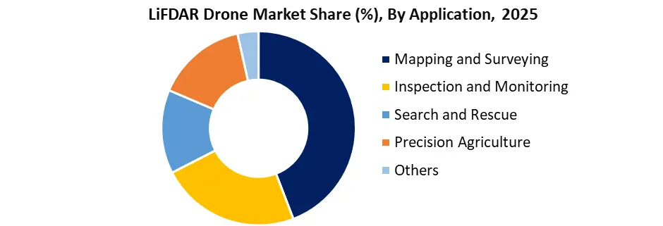
| Dominant Application Segment (2025) | Mapping & Surveying (Topographic Mapping, DEM, Geospatial Data Collection) | ↑ Market Leader |
| Second Largest Segment | Inspection & Monitoring (Infrastructure Inspection, Asset Monitoring, UAV LiDAR Systems) | ↑ Rapid Adoption |
| Third Largest Segment | Precision Agriculture (3D Mapping Drones, Crop Monitoring, Remote Sensing) | ↑ Increasing Demand |
| LiDAR UAV Technology Adoption | Rapid adoption of airborne laser scanning, point cloud data, and AI-powered drone analytics | ↑ Transformational Growth |
| AI & Machine Learning Integration | Enabling automated feature extraction, predictive analytics, and real-time decision-making | ↑ Industry Disruption |
| Digital Twin & 3D Mapping Growth | Increasing use of 3D mapping drones and digital twin ecosystems in infrastructure | ↑ Expanding Adoption |
| Drone-as-a-Service (DaaS) Growth | Rising demand for subscription-based LiDAR drone solutions and cloud-based processing | ↑ Scalable Expansion |
| Cloud-Based LiDAR Data Processing | Strong adoption of cloud platforms and real-time geospatial analytics systems | ↑ Dominant Deployment Model |
| Average ROI Realization | 10–16 Months Implementation Cycle | ↑ Attractive Investment |
| Survey Cost Reduction Potential | 30–50% Savings through UAV-based LiDAR mapping | ↑ Cost Efficiency |
| Key End-Use Industries | Construction, Mining, Agriculture, Forestry, Infrastructure, Smart Cities | ↑ Broad Adoption |
| Competitive Landscape | Presence of key players such as DJI, Trimble, Leica Geosystems, RIEGL, Velodyne LiDAR | ↑ Innovation Driven |
Key Market Drivers for the LiDAR Drone Market
The primary drivers of the LiDAR Drone Market Growth include the rising demand for high-precision geospatial data, increasing adoption of 3D mapping drones, and the need for cost-efficient surveying solutions. Industries such as construction, mining, and agriculture are rapidly shifting toward LiDAR UAV mapping solutions to improve operational efficiency and decision-making. The integration of AI-powered analytics, cloud-based processing, and real-time aerial data collection technologies is further accelerating adoption. Additionally, the growing emphasis on automation and digital transformation is positioning LiDAR drones as a critical tool across multiple industrial applications.
Market Restraints for the LiDAR Drone Market
The LiDAR Drone Market faces challenges related to high initial investment costs, including expensive LiDAR sensors, UAV platforms, and data processing infrastructure. Additionally, regulatory restrictions on drone operations, particularly in urban and defense-sensitive areas, limit large-scale deployment. The complexity of point cloud data processing and the requirement for skilled professionals also act as barriers to adoption. Furthermore, integration challenges with existing enterprise systems can slow down digital transformation initiatives, impacting overall LiDAR Drone Market Growth in price-sensitive regions.
Market Opportunities for the LiDAR Drone Market
The LiDAR Drone Market Opportunities are expanding with the rapid adoption of smart cities, digital twins, and autonomous infrastructure monitoring systems. Emerging economies, particularly in Asia-Pacific, present strong growth potential due to increasing investments in infrastructure development and precision agriculture. The integration of AI, 5G, and edge computing is enabling real-time analytics, opening new avenues in defense, disaster management, and environmental monitoring. Additionally, the rise of Drone-as-a-Service (DaaS) models is lowering entry barriers, allowing SMEs to adopt LiDAR drone solutions, further accelerating market expansion.
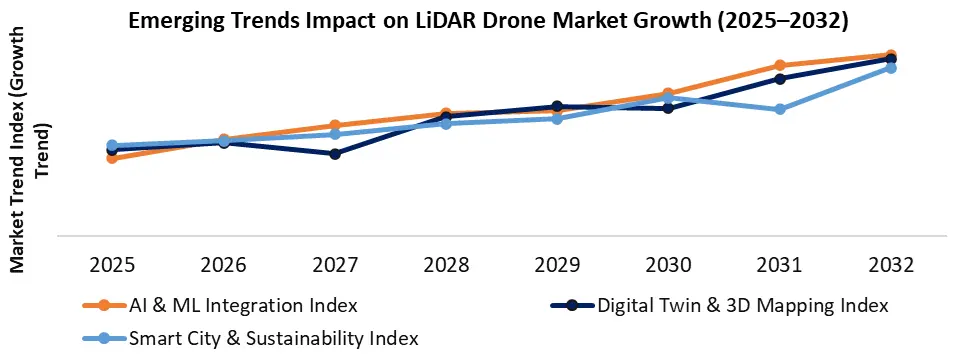
Emerging Trends Shaping the LiDAR Drone Industry
• Integration of AI and Machine Learning
AI is enabling automated feature extraction, real-time analytics, and predictive modeling, significantly enhancing the LiDAR Drone Market Forecast 2032 outlook.
• Growth of Digital Twin & 3D Mapping Technologies
The adoption of 3D mapping drones and digital twin ecosystems is transforming infrastructure development, enabling real-time simulation and planning.
• Expansion of Smart City & Sustainability Applications
LiDAR drones are increasingly used in urban planning, environmental monitoring, and disaster management, supporting sustainable development initiatives.
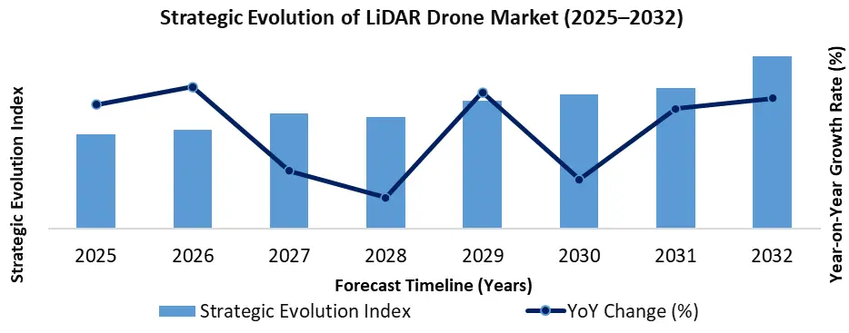
Strategic Evolution of LiDAR Drone Market
Beyond technological trends, the LiDAR Drone Market is evolving into a mission-critical decision-intelligence platform rather than just a mapping tool. Enterprises are increasingly integrating LiDAR UAV data with GIS platforms, ERP systems, and digital asset management solutions, enabling seamless workflow automation and data-driven decision-making.
The emergence of real-time LiDAR data processing, edge AI capabilities, and cloud-based analytics platforms is transforming the market into a real-time geospatial intelligence ecosystem. This evolution is particularly significant for industries requiring high-frequency data collection, such as defense surveillance, disaster response, and infrastructure monitoring.
Additionally, the shift toward autonomous drone operations and AI-enabled flight-planning systems is reducing reliance on human pilots, further enhancing scalability and operational efficiency. This positions the LiDAR Drone Industry as a strategic enabler of Industry 4.0 and smart infrastructure development.
 6
6
Strategic Cost & ROI Analysis
The LiDAR Drone Market Analysis highlights strong return on investment driven by:
• Survey Cost Reduction (30–50%)
• Faster Project Completion (up to 70%)
• Reduced Labor Dependency
• Improved Data Accuracy (95%+)
Most organizations achieve ROI within 12–18 months, making LiDAR drones for industrial applications a highly attractive investment. The use of AI-powered LiDAR drone analytics further enhances cost efficiency by minimizing rework and improving decision accuracy.
Integration of Drone Data with Enterprise Digital Platforms (ERP & GIS Ecosystems)
The increasing integration of UAV data services with enterprise systems such as ERP, GIS, and digital asset management platforms is redefining how organizations utilize aerial intelligence. Companies are embedding drone data insights directly into business workflows, enabling seamless decision-making across operations.
This integration supports:
• End-to-end workflow automation in construction and infrastructure projects
• Enhanced geospatial intelligence through GIS-based drone mapping services
• Data-driven asset lifecycle management and predictive maintenance
As a result, the LiDAR Drone Market Growth is increasingly driven by its role as a strategic data layer within enterprise digital transformation initiatives, rather than just a standalone data collection tool.
Strategic Cost & ROI Analysis in the LiDAR Drone Market
One of the key decision-making factors in the Global LiDAR Drone Market is Return on Investment (ROI).
Organizations achieve value through:
• Survey Cost Reduction (30–50%)
• Faster Project Completion (up to 60%)
• Reduced Labor Costs
• Improved Data Accuracy (up to 95%)
The LiDAR Drone Market Analysis indicates that most enterprises achieve ROI within 10–16 months, making it a highly attractive investment.
The adoption of AI in the LiDAR Drone Market further enhances cost efficiency by reducing manual intervention and improving predictive capabilities.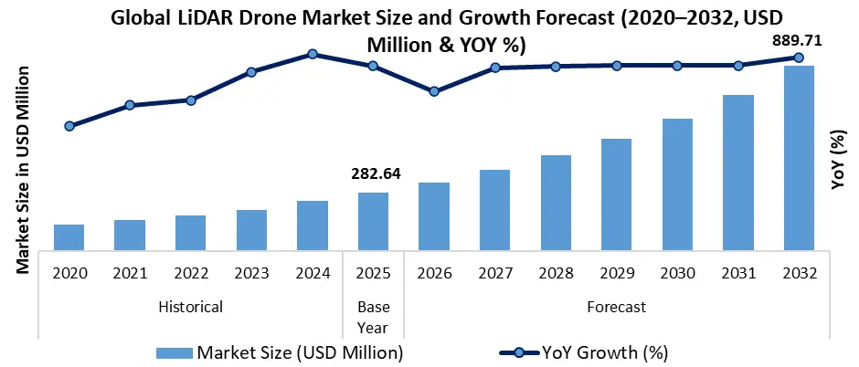
LiDAR Drone Market Segmentation Analysis
The Mapping and Surveying segment dominated the LiDAR Drone Market in the year 2025, driven by rising demand for topographic mapping, digital elevation models (DEM), and high-resolution geospatial data collection across construction, mining, and infrastructure projects. The Inspection and Monitoring segment holds the second position, supported by increasing use of UAV LiDAR systems for infrastructure inspection, asset monitoring, and real-time aerial analytics. The Precision Agriculture segment ranks third, fueled by the adoption of 3D mapping drones, crop monitoring, and remote sensing technology, enabling data-driven farming and improved productivity within the LiDAR UAV Market.
LiDAR Drone Market Regional Insights
• North America LiDAR Drone Market – Market Leader
North America dominated due to advanced geospatial technology adoption, strong presence of LiDAR drone manufacturers, and high investment in AI-powered UAV solutions.
• Europe LiDAR Drone Market – Sustainability & Compliance Focus
Europe is driven by environmental monitoring, smart infrastructure, and strict regulatory frameworks supporting sustainable growth.
• Asia Pacific LiDAR Drone Market – Fastest Growing Region
Countries like India and China are experiencing rapid growth due to smart city initiatives, agricultural modernization, and infrastructure expansion, making it the fastest-growing region.
• Middle East & Africa – Emerging Growth Hub
Increasing investments in oil & gas, mining, and large-scale infrastructure projects are driving adoption of LiDAR drone technology.
LiDAR Drone Market Competitive Landscape
The Global LiDAR Drone Market Competitive Landscape is highly dynamic, with companies focusing on sensor innovation, AI integration, and cloud-based data platforms.
Leading players include:
• DJI – Leader in UAV platforms and LiDAR integration
• Trimble – Strong in geospatial and surveying solutions
• Leica Geosystems – High-precision LiDAR systems
• RIEGL – Advanced UAV LiDAR sensors
• Velodyne LiDAR – Pioneer in LiDAR sensor technology
These companies are driving innovation in the LiDAR Drone Industry, enhancing market share, technological advancements, and competitive positioning.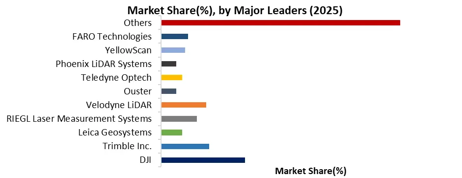
Recent Key Development:
| Date | Company | Development | Impact |
| Mar-25 | Leica Geosystems | Launched single-photon LiDAR technology with ultra-high point density | Significantly improved large-scale mapping accuracy and national survey capabilities |
| Feb-25 | GeoCue Group | Partnered with Clogworks to integrate UAV platforms with LiDAR data processing software | Enhanced end-to-end workflow efficiency and faster data delivery |
| Jan-25 | Hesai Technology | Reported strong LiDAR shipment growth and production scale expansion | Strengthened supply chain capabilities and reduced LiDAR sensor costs |
| 2024 | DJI | Introduced advanced LiDAR payload systems such as Zenmuse L2/L3 for enterprise drones | Improved high-precision mapping, vegetation penetration, and surveying efficiency |
| 2024 | Trimble (Applanix) | Advanced georeferencing and positioning solutions for UAV LiDAR workflows | Enhanced accuracy in topographic mapping and corridor mapping applications |
| 2025 | GreenValley International | Expanded LiDAR-UAV integration solutions for enterprise mapping | Strengthened adoption of integrated LiDAR drone systems across industries |
LiDAR Drone Market Scope: Inquire before buying
| LiDAR Drone Market | |||
|---|---|---|---|
| Report Coverage | Details | ||
| Base Year: | 2025 | Forecast Period: | 2026-2032 |
| Historical Data: | 2020 to 2025 | Market Size in 2025: | USD282.64 Mn. |
| Forecast Period 2026 to 2032 CAGR: | 17.8% | Market Size in 2032: | USD 889.71 Mn. |
| Segments Covered: | by Drone Type | Fixed-wing Rotary-wing |
|
| by Range | Short-range (less than 1 km) Medium-range (1-5 km) Long-range (over 5 km) |
||
| by Payload | Cameras LiDAR Sensors Thermal Imaging Cameras Others |
||
| by Propulsion System | Electric Hybrid Fuel Cell |
||
| by Application | Mapping and Surveying Inspection and Monitoring Search and Rescue Precision Agriculture Others |
||
North America (United States, Canada, and Mexico)
Europe (UK, France, Germany, Italy, Spain, Sweden, Austria, and the rest of Europe)
Asia Pacific (China, South Korea, Japan, India, Australia, Indonesia, Malaysia, Vietnam, Taiwan, Bangladesh, Pakistan, and the Rest of APAC)
Middle East and Africa (South Africa, GCC, Egypt, Nigeria, and the Rest of ME&A)
South America (Brazil, Argentina, and the rest of South America)
Key Players/Competitors Profiles Covered in the LiDAR Drone Market Report in Strategic Perspective
Major Global Leaders (Core Market Players)
1. DJI
2. Trimble Inc.
3. Leica Geosystems
4. RIEGL Laser Measurement Systems
5. Velodyne LiDAR
6. Ouster
7. Teledyne Optech
8. Phoenix LiDAR Systems
9. YellowScan
10. FARO Technologies
Advanced LiDAR Sensor & Technology Providers
11. Cepton Technologies
12. Quanergy Solutions
13. Innoviz Technologies
14. Luminar Technologies
15. RoboSense
16. Hesai Technology
17. LeddarTech
18. Livox
19. Benewake
Drone & UAV Platform Companies
20. Parrot
21. senseFly
22. Delair
23. Microdrones
24. Terra Drone
25. Quantum Systems
26. Wingtra
27. JOUAV
Geospatial, Mapping & Analytics Companies
28. GeoCue Group
29. Aerometrex
30. Geodetics
31. GeoSLAM
32. Quantum Spatial
33. Routescene
34. Topodrone
35. Mapix Technologies
Specialized LiDAR UAV & Integration Providers
36. Sick AG
37. Topcon Corporation
38. LiDARUSA
39. Geosun
40. SureStar
41. Inertial Labs
42. GreenValley International
43. CHC Navigation
44. Aerolaser Systems
Emerging & Niche Market Players
45. Aeva Technologies
46. Ceinsys Tech
47. Skycatch
48. Flyability
49. Emesent
50. Exyn Technologies
51. NextCore
52. Rock Robotic
53. RedTail LiDAR Systems
Frequently Asked Questions
Q) What is the LiDAR Drone Market and how does it work?
Ans. The LiDAR Drone Market refers to the use of UAV-mounted LiDAR (Light Detection and Ranging) systems for high-precision aerial mapping, topographic surveying, and geospatial data collection. These drones use airborne laser scanning technology to generate high-density point cloud data and digital elevation models (DEM), enabling accurate terrain analysis even in dense vegetation and complex environments.
Q) What is the market size and growth rate of the LiDAR Drone Market?
Ans. The Global LiDAR Drone Market Size was valued at USD 282.64 Million in 2025 and is projected to reach USD 889.71 Million by 2032, growing at a CAGR of 17.8%. This growth is driven by increasing demand for real-time aerial surveying, AI-powered drone analytics, and high-resolution geospatial intelligence solutions.
Q) Which industries are driving the demand for LiDAR drones?
Ans. Key industries driving the LiDAR Drone Market Growth include construction, mining, agriculture, forestry, infrastructure inspection, and smart cities. These sectors rely on LiDAR mapping drones, 3D terrain modeling, and remote sensing technologies to improve operational efficiency, decision-making, and project accuracy.
Q) What are the key benefits of using LiDAR drones over traditional surveying methods?
Ans. LiDAR drones offer significant advantages such as 30–50% survey cost reduction, up to 60–70% faster project completion, and data accuracy exceeding 95%. They enable real-time aerial data collection, reduce manual labor, and provide high-resolution geospatial insights, making them more efficient than traditional surveying techniques.
Q) What are the key trends shaping the LiDAR Drone Market?
Ans. Major trends include the integration of AI and machine learning, adoption of digital twin and 3D mapping technologies, and expansion of smart city and sustainability applications. Additionally, advancements in cloud-based LiDAR data processing, edge AI, and autonomous UAV systems are transforming the market into a real-time geospatial intelligence ecosystem.