Global Aerial Imaging Market
1. Preface
1.1. Report Scope and Market Segmentation
1.2. Research Highlight
1.3. Research Objectives
1.4. Key Questions Answered
2. Assumptions and Research Methodology
2.1. Report Assumptions
2.2. Abbreviations Used
2.3. Research Methodology
3. Executive Summary
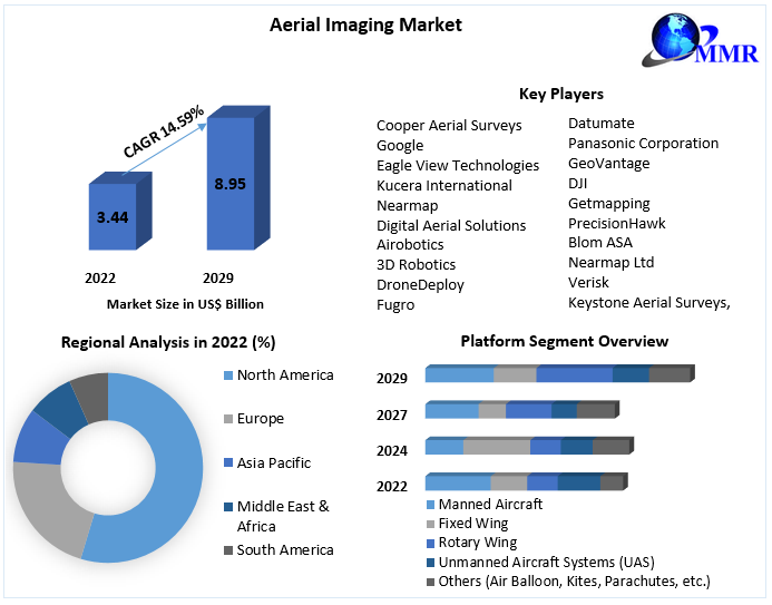
3.1. Global Aerial Imaging Market Size, By Market Value (US$ Bn) and Market , By Region
4. Market Overview
4.1. Introduction
4.2. Market Indicator
4.3. Drivers and Restraints Snapshot Analysis
4.3.1. Drivers
4.3.2. Restraints
4.3.3. Opportunities
4.3.4. Porter’s Analysis
4.3.5. Value Chain Analysis
4.3.6. SWOT Analysis
4.3.7. Key Trends in Global Aerial Imaging Market
5. Global Aerial Imaging Market Analysis and Forecast
5.1. Global Aerial Imaging Market Analysis and Forecast
5.2. Global Aerial Imaging Market Size & Y-o-Y Growth Analysis
5.2.1. North America
5.2.2. Europe
5.2.3. Asia Pacific
5.2.4. Middle East & Africa
5.2.5. Latin America
6. Global Aerial Imaging Market Analysis and Forecast, By Application
6.1. Introduction and Definition
6.2. Key Findings
6.3. Global Aerial Imaging Market Value Share Analysis, By Application
6.4. Global Aerial Imaging Market Size (US$ Bn) Forecast, By Application
6.5. Global Aerial Imaging Market Analysis, By Application
6.6. Global Aerial Imaging Market Attractiveness Analysis, By Application
7. Global Aerial Imaging Market Analysis and Forecast, By Platform
7.1. Introduction and Definition
7.2. Key Findings
7.3. Global Aerial Imaging Market Value Share Analysis, By Platform
7.4. Market Size (US$ Bn) Forecast, By Platform
7.5. Market Analysis, By Platform
7.6. Global Aerial Imaging Market Attractiveness Analysis, By Platform
8. Global Aerial Imaging Market Analysis and Forecast, By End-User
8.1. Introduction and Definition
8.2. Key Findings
8.3. Global Aerial Imaging Market Value Share Analysis, By End-User
8.4. Global Aerial Imaging Market Size (US$ Bn) Forecast, By End-User
8.5. Market Analysis, By End-User
8.6. Global Aerial Imaging Market Attractiveness Analysis, By End-User
9. Global Aerial Imaging Market Analysis, By Region
9.1. Key Findings
9.2. Global Aerial Imaging Market Value Share Analysis, By Region
9.3. Global Aerial Imaging Market Size (US$ Bn) Forecast, By Region
9.4. Global Aerial Imaging Market Analysis, By Region
9.5. Global Aerial Imaging Market Attractiveness Analysis, By Region
10. North America Aerial Imaging Market Analysis
10.1. Key Findings
10.2. North America Aerial Imaging Market Overview
10.3. North America Aerial Imaging Market Value Share Analysis, By Application
10.4. North America Aerial Imaging Market Forecast, By Application
10.4.1. Geospatial Mapping
10.4.2. Disaster Management
10.4.3. Energy and Resource Management
10.4.4. Surveillance and Monitoring
10.4.5. Others (Habitat, Power Line, Advertising, and Photography)
10.5. North America Aerial Imaging Market Value Share Analysis, By Platform
10.6. North America Aerial Imaging Market Forecast, By Platform
10.6.1. Manned Aircraft
10.6.2. Fixed Wing
10.6.3. Rotary Wing
10.6.4. Unmanned Aircraft Systems (UAS)
10.6.5. Others (Air Balloon, Kites, Parachutes, etc.)
10.7. North America Aerial Imaging Market Value Share Analysis, By End-User
10.8. North America Aerial Imaging Market Forecast, By End-User
10.8.1. Government
10.8.2. Energy
10.8.3. Defense
10.8.4. Agriculture & Forestry
10.8.5. Civil Engineering & Archaeology
10.8.6. Media & Entertainment
10.8.7. Others (Insurance, and Tourism)
10.9. North America Aerial Imaging Market Value Share Analysis, By Country
10.10. North America Aerial Imaging Market Forecast, By Country
10.10.1.1. U.S.
10.10.1.2. Canada.
10.11. U.S. Aerial Imaging Market Forecast, By Application
10.11.1. Geospatial Mapping
10.11.2. Disaster Management
10.11.3. Energy and Resource Management
10.11.4. Surveillance and Monitoring
10.11.5. Others (Habitat, Power Line, Advertising, and Photography)
10.12. U.S. Aerial Imaging Market Forecast, By Platform
10.12.1. Manned Aircraft
10.12.2. Fixed Wing
10.12.3. Rotary Wing
10.12.4. Unmanned Aircraft Systems (UAS)
10.12.5. Others (Air Balloon, Kites, Parachutes, etc.)
10.13. U.S. Aerial Imaging Market Forecast, By End-User
10.13.1. Government
10.13.2. Energy
10.13.3. Defense
10.13.4. Agriculture & Forestry
10.13.5. Civil Engineering & Archaeology
10.13.6. Media & Entertainment
10.13.7. Others (Insurance, and Tourism)
10.14. Canada Aerial Imaging Market Forecast, By Application
10.14.1. Geospatial Mapping
10.14.2. Disaster Management
10.14.3. Energy and Resource Management
10.14.4. Surveillance and Monitoring
10.14.5. Others (Habitat, Power Line, Advertising, and Photography)
10.15. Canada Aerial Imaging Market Forecast, By Platform
10.15.1. Manned Aircraft
10.15.2. Fixed Wing
10.15.3. Rotary Wing
10.15.4. Unmanned Aircraft Systems (UAS)
10.15.5. Others (Air Balloon, Kites, Parachutes, etc.)
10.16. Canada Aerial Imaging Market Forecast, By End-User
10.16.1. Government
10.16.2. Energy
10.16.3. Defense
10.16.4. Agriculture & Forestry
10.16.5. Civil Engineering & Archaeology
10.16.6. Media & Entertainment
10.16.7. Others (Insurance, and Tourism)
10.17. North America Aerial Imaging Market Attractiveness Analysis
10.17.1. By Application
10.17.2. By Platform
10.17.3. By End-User
10.18. PEST Analysis
11. Europe Aerial Imaging Market Analysis
11.1. Key Findings
11.2. Europe Aerial Imaging Market Overview
11.3. Europe Aerial Imaging Market Value Share Analysis, By Application
11.4. Europe Aerial Imaging Market Forecast, By Application
11.4.1. Geospatial Mapping
11.4.2. Disaster Management
11.4.3. Energy and Resource Management
11.4.4. Surveillance and Monitoring
11.4.5. Others (Habitat, Power Line, Advertising, and Photography)
11.5. Europe Aerial Imaging Market Value Share Analysis, By Platform
11.6. Europe Aerial Imaging Market Forecast, By Platform
11.6.1. Manned Aircraft
11.6.2. Fixed Wing
11.6.3. Rotary Wing
11.6.4. Unmanned Aircraft Systems (UAS)
11.6.5. Others (Air Balloon, Kites, Parachutes, etc.)
11.7. Europe Aerial Imaging Market Value Share Analysis, By End-User
11.8. Europe Aerial Imaging Market Forecast, By End-User
11.8.1. Government
11.8.2. Energy
11.8.3. Defense
11.8.4. Agriculture & Forestry
11.8.5. Civil Engineering & Archaeology
11.8.6. Media & Entertainment
11.8.7. Others (Insurance, and Tourism)
11.9. Europe Aerial Imaging Market Forecast, By Country
11.9.1. Germany
11.9.2. U.K.
11.9.3. France
11.9.4. Italy
11.9.5. Spain
11.9.6. Rest of Europe
11.10. Europe Aerial Imaging Market Analysis, By Country/ Sub-region
11.11. Germany Aerial Imaging Market Forecast, By Application
11.11.1. Geospatial Mapping
11.11.2. Disaster Management
11.11.3. Energy and Resource Management
11.11.4. Surveillance and Monitoring
11.11.5. Others (Habitat, Power Line, Advertising, and Photography)
11.12. Germany Aerial Imaging Market Forecast, By Platform
11.12.1. Manned Aircraft
11.12.2. Fixed Wing
11.12.3. Rotary Wing
11.12.4. Unmanned Aircraft Systems (UAS)
11.12.5. Others (Air Balloon, Kites, Parachutes, etc.)
11.13. Germany Aerial Imaging Market Forecast, By End-User
11.13.1. Government
11.13.2. Energy
11.13.3. Defense
11.13.4. Agriculture & Forestry
11.13.5. Civil Engineering & Archaeology
11.13.6. Media & Entertainment
11.13.7. Others (Insurance, and Tourism)
11.14. U.K. Aerial Imaging Market Forecast, By Application
11.14.1. Geospatial Mapping
11.14.2. Disaster Management
11.14.3. Energy and Resource Management
11.14.4. Surveillance and Monitoring
11.14.5. Others (Habitat, Power Line, Advertising, and Photography)
11.15. U.K. Aerial Imaging Market Forecast, By Platform
11.15.1. Manned Aircraft
11.15.2. Fixed Wing
11.15.3. Rotary Wing
11.15.4. Unmanned Aircraft Systems (UAS)
11.15.5. Others (Air Balloon, Kites, Parachutes, etc.)
11.16. U.K. Aerial Imaging Market Forecast, By End-User
11.16.1. Government
11.16.2. Energy
11.16.3. Defense
11.16.4. Agriculture & Forestry
11.16.5. Civil Engineering & Archaeology
11.16.6. Media & Entertainment
11.16.7. Others (Insurance, and Tourism)
11.17. France Aerial Imaging Market Forecast, By Application
11.17.1. Geospatial Mapping
11.17.2. Disaster Management
11.17.3. Energy and Resource Management
11.17.4. Surveillance and Monitoring
11.17.5. Others (Habitat, Power Line, Advertising, and Photography)
11.18. France Aerial Imaging Market Forecast, By Platform
11.18.1. Manned Aircraft
11.18.2. Fixed Wing
11.18.3. Rotary Wing
11.18.4. Unmanned Aircraft Systems (UAS)
11.18.5. Others (Air Balloon, Kites, Parachutes, etc.)
11.19. France Aerial Imaging Market Forecast, By End-User
11.19.1. Government
11.19.2. Energy
11.19.3. Defense
11.19.4. Agriculture & Forestry
11.19.5. Civil Engineering & Archaeology
11.19.6. Media & Entertainment
11.19.7. Others (Insurance, and Tourism)
11.20. Italy Aerial Imaging Market Forecast, By Application
11.20.1. Geospatial Mapping
11.20.2. Disaster Management
11.20.3. Energy and Resource Management
11.20.4. Surveillance and Monitoring
11.20.5. Others (Habitat, Power Line, Advertising, and Photography)
11.21. Italy Aerial Imaging Market Forecast, By Platform
11.21.1. Manned Aircraft
11.21.2. Fixed Wing
11.21.3. Rotary Wing
11.21.4. Unmanned Aircraft Systems (UAS)
11.21.5. Others (Air Balloon, Kites, Parachutes, etc.)
11.22. Italy Aerial Imaging Market Forecast, By End-User
11.22.1. Government
11.22.2. Energy
11.22.3. Defense
11.22.4. Agriculture & Forestry
11.22.5. Civil Engineering & Archaeology
11.22.6. Media & Entertainment
11.22.7. Others (Insurance, and Tourism)
11.23. Spain Aerial Imaging Market Forecast, By Application
11.23.1. Geospatial Mapping
11.23.2. Disaster Management
11.23.3. Energy and Resource Management
11.23.4. Surveillance and Monitoring
11.23.5. Others (Habitat, Power Line, Advertising, and Photography)
11.24. Spain Aerial Imaging Market Forecast, By Platform
11.24.1. Manned Aircraft
11.24.2. Fixed Wing
11.24.3. Rotary Wing
11.24.4. Unmanned Aircraft Systems (UAS)
11.24.5. Others (Air Balloon, Kites, Parachutes, etc.)
11.25. Spain Aerial Imaging Market Forecast, By End-User
11.25.1. Government
11.25.2. Energy
11.25.3. Defense
11.25.4. Agriculture & Forestry
11.25.5. Civil Engineering & Archaeology
11.25.6. Media & Entertainment
11.25.7. Others (Insurance, and Tourism)
11.26. Rest of Europe Aerial Imaging Market Forecast, By Application
11.26.1. Geospatial Mapping
11.26.2. Disaster Management
11.26.3. Energy and Resource Management
11.26.4. Surveillance and Monitoring
11.26.5. Others (Habitat, Power Line, Advertising, and Photography)
11.27. Rest of Europe Aerial Imaging Market Forecast, By Platform
11.27.1. Manned Aircraft
11.27.2. Fixed Wing
11.27.3. Rotary Wing
11.27.4. Unmanned Aircraft Systems (UAS)
11.27.5. Others (Air Balloon, Kites, Parachutes, etc.)
11.28. Rest of Europe Aerial Imaging Market Forecast, By End-User
11.28.1. Government
11.28.2. Energy
11.28.3. Defense
11.28.4. Agriculture & Forestry
11.28.5. Civil Engineering & Archaeology
11.28.6. Media & Entertainment
11.28.7. Others (Insurance, and Tourism)
11.29. Europe Aerial Imaging Market Attractiveness Analysis
11.29.1. By Application
11.29.2. By End-User
11.29.3. By Platform
11.30. PEST Analysis
12. Asia Pacific Aerial Imaging Market Analysis
12.1. Key Findings
12.2. Asia Pacific Aerial Imaging Market Overview
12.3. Asia Pacific Aerial Imaging Market Value Share Analysis, By Application
12.4. Asia Pacific Aerial Imaging Market Forecast, By Application
12.4.1. Geospatial Mapping
12.4.2. Disaster Management
12.4.3. Energy and Resource Management
12.4.4. Surveillance and Monitoring
12.4.5. Others (Habitat, Power Line, Advertising, and Photography)
12.5. Asia Pacific Aerial Imaging Market Value Share Analysis, By Platform
12.6. Asia Pacific Aerial Imaging Market Forecast, By Platform
12.6.1. Manned Aircraft
12.6.2. Fixed Wing
12.6.3. Rotary Wing
12.6.4. Unmanned Aircraft Systems (UAS)
12.6.5. Others (Air Balloon, Kites, Parachutes, etc.)
12.7. Asia Pacific Aerial Imaging Market Value Share Analysis, By End-User
12.8. Asia Pacific Aerial Imaging Market Forecast, By End-User
12.8.1. Government
12.8.2. Energy
12.8.3. Defense
12.8.4. Agriculture & Forestry
12.8.5. Civil Engineering & Archaeology
12.8.6. Media & Entertainment
12.8.7. Others (Insurance, and Tourism)
12.9. Asia Pacific Aerial Imaging Market Value Share Analysis, By Country
12.10. Asia Pacific Aerial Imaging Market Forecast, By Country
12.10.1. China.
12.10.2. India.
12.10.3. Japan.
12.10.4. ASEAN.
12.10.5. Rest of Asia Pacific.
12.11. Asia Pacific Aerial Imaging Market Analysis, By Country/ Sub-region
12.12. China Aerial Imaging Market Forecast, By Application
12.12.1. Geospatial Mapping
12.12.2. Disaster Management
12.12.3. Energy and Resource Management
12.12.4. Surveillance and Monitoring
12.12.5. Others (Habitat, Power Line, Advertising, and Photography)
12.13. China Aerial Imaging Market Forecast, By Platform
12.13.1. Manned Aircraft
12.13.2. Fixed Wing
12.13.3. Rotary Wing
12.13.4. Unmanned Aircraft Systems (UAS)
12.13.5. Others (Air Balloon, Kites, Parachutes, etc.)
12.14. China Aerial Imaging Market Forecast, By End-User
12.14.1. Government
12.14.2. Energy
12.14.3. Defense
12.14.4. Agriculture & Forestry
12.14.5. Civil Engineering & Archaeology
12.14.6. Media & Entertainment
12.14.7. Others (Insurance, and Tourism)
12.13. India Aerial Imaging Market Forecast, By Application
12.13.1. Geospatial Mapping
12.13.2. Disaster Management
12.13.3. Energy and Resource Management
12.13.4. Surveillance and Monitoring
12.13.5. Others (Habitat, Power Line, Advertising, and Photography)
12.15. India Aerial Imaging Market Forecast, By Platform
12.15.1. Manned Aircraft
12.15.2. Fixed Wing
12.15.3. Rotary Wing
12.15.4. Unmanned Aircraft Systems (UAS)
12.15.5. Others (Air Balloon, Kites, Parachutes, etc.)
12.16. India Aerial Imaging Market Forecast, By End-User
12.16.1. Government
12.16.2. Energy
12.16.3. Defense
12.16.4. Agriculture & Forestry
12.16.5. Civil Engineering & Archaeology
12.16.6. Media & Entertainment
12.16.7. Others (Insurance, and Tourism)
12.14. Japan Aerial Imaging Market Forecast, By Application
12.14.1. Geospatial Mapping
12.14.2. Disaster Management
12.14.3. Energy and Resource Management
12.14.4. Surveillance and Monitoring
12.14.5. Others (Habitat, Power Line, Advertising, and Photography)
12.17. Japan Aerial Imaging Market Forecast, By Platform
12.17.1. Manned Aircraft
12.17.2. Fixed Wing
12.17.3. Rotary Wing
12.17.4. Unmanned Aircraft Systems (UAS)
12.17.5. Others (Air Balloon, Kites, Parachutes, etc.)
12.18. Japan Aerial Imaging Market Forecast, By End-User
12.18.1. Government
12.18.2. Energy
12.18.3. Defense
12.18.4. Agriculture & Forestry
12.18.5. Civil Engineering & Archaeology
12.18.6. Media & Entertainment
12.18.7. Others (Insurance, and Tourism)
12.15. ASEAN Aerial Imaging Market Forecast, By Application
12.15.1. Geospatial Mapping
12.15.2. Disaster Management
12.15.3. Energy and Resource Management
12.15.4. Surveillance and Monitoring
12.15.5. Others (Habitat, Power Line, Advertising, and Photography)
12.19. ASEAN Aerial Imaging Market Forecast, By Platform
12.19.1. Manned Aircraft
12.19.2. Fixed Wing
12.19.3. Rotary Wing
12.19.4. Unmanned Aircraft Systems (UAS)
12.19.5. Others (Air Balloon, Kites, Parachutes, etc.)
12.20. ASEAN Aerial Imaging Market Forecast, By End-User
12.20.1. Government
12.20.2. Energy
12.20.3. Defense
12.20.4. Agriculture & Forestry
12.20.5. Civil Engineering & Archaeology
12.20.6. Media & Entertainment
12.20.7. Others (Insurance, and Tourism)
12.16. Rest of Asia Aerial Imaging Market Forecast, By Application
12.16.1. Geospatial Mapping
12.16.2. Disaster Management
12.16.3. Energy and Resource Management
12.16.4. Surveillance and Monitoring
12.16.5. Others (Habitat, Power Line, Advertising, and Photography)
12.21. Rest of Asia Aerial Imaging Market Forecast, By Platform
12.21.1. Manned Aircraft
12.21.2. Fixed Wing
12.21.3. Rotary Wing
12.21.4. Unmanned Aircraft Systems (UAS)
12.21.5. Others (Air Balloon, Kites, Parachutes, etc.)
12.22. Rest of Asia Aerial Imaging Market Forecast, By End-User
12.22.1. Government
12.22.2. Energy
12.22.3. Defense
12.22.4. Agriculture & Forestry
12.22.5. Civil Engineering & Archaeology
12.22.6. Media & Entertainment
12.22.7. Others (Insurance, and Tourism)
12.23. Asia Aerial Imaging Market Attractiveness Analysis
12.23.1. By Application
12.23.2. By Platform
12.23.3. By End-User
12.24. PEST Analysis
13. Middle East & Africa Aerial Imaging Market Analysis
13.13. Key Findings
13.14. Middle East & Africa Aerial Imaging Market Overview
13.15. Middle East & Africa Aerial Imaging Market Value Share Analysis, By Application
13.16. Middle East & Africa Aerial Imaging Market Forecast, By Application
13.16.1. Geospatial Mapping
13.16.2. Disaster Management
13.16.3. Energy and Resource Management
13.16.4. Surveillance and Monitoring
13.16.5. Others (Habitat, Power Line, Advertising, and Photography)
13.17. Middle East & Africa Aerial Imaging Market Value Share Analysis, By Platform
13.18. Middle East & Africa Aerial Imaging Market Forecast, By Platform
13.18.1. Manned Aircraft
13.18.2. Fixed Wing
13.18.3. Rotary Wing
13.18.4. Unmanned Aircraft Systems (UAS)
13.18.5. Others (Air Balloon, Kites, Parachutes, etc.)
13.19. Middle East & Africa Aerial Imaging Market Value Share Analysis, By End-User
13.20. Middle East & Africa Aerial Imaging Market Forecast, By End-User
13.20.1. Government
13.20.2. Energy
13.20.3. Defense
13.20.4. Agriculture & Forestry
13.20.5. Civil Engineering & Archaeology
13.20.6. Media & Entertainment
13.20.7. Others (Insurance, and Tourism)
13.21. Middle East & Africa Aerial Imaging Market Value Share Analysis, By Country
13.22. Middle East & Africa Aerial Imaging Market Forecast, By Country
13.22.1. GCC.
13.22.2. South Africa.
13.22.3. Rest of Middle East & Africa.
13.23. Middle East & Africa Aerial Imaging Market Analysis, By Country/ Sub-region
13.24. GCC Aerial Imaging Market Forecast, By Application
13.24.1. Geospatial Mapping
13.24.2. Disaster Management
13.24.3. Energy and Resource Management
13.24.4. Surveillance and Monitoring
13.24.5. Others (Habitat, Power Line, Advertising, and Photography)
13.25. GCC Aerial Imaging Market Forecast, By Platform
13.25.1. Manned Aircraft
13.25.2. Fixed Wing
13.25.3. Rotary Wing
13.25.4. Unmanned Aircraft Systems (UAS)
13.25.5. Others (Air Balloon, Kites, Parachutes, etc.)
13.26. GCC Aerial Imaging Market Forecast, By End-User
13.26.1. Government
13.26.2. Energy
13.26.3. Defense
13.26.4. Agriculture & Forestry
13.26.5. Civil Engineering & Archaeology
13.26.6. Media & Entertainment
13.26.7. Others (Insurance, and Tourism)
13.27. South Africa Aerial Imaging Market Forecast, By Application
13.27.1. Geospatial Mapping
13.27.2. Disaster Management
13.27.3. Energy and Resource Management
13.27.4. Surveillance and Monitoring
13.27.5. Others (Habitat, Power Line, Advertising, and Photography)
13.28. South Africa Aerial Imaging Market Forecast, By Platform
13.28.1. Manned Aircraft
13.28.2. Fixed Wing
13.28.3. Rotary Wing
13.28.4. Unmanned Aircraft Systems (UAS)
13.28.5. Others (Air Balloon, Kites, Parachutes, etc.)
13.29. South Africa Aerial Imaging Market Forecast, By End-User
13.29.1. Government
13.29.2. Energy
13.29.3. Defense
13.29.4. Agriculture & Forestry
13.29.5. Civil Engineering & Archaeology
13.29.6. Media & Entertainment
13.29.7. Others (Insurance, and Tourism)
13.30. Rest of Middle East & Africa Aerial Imaging Market Forecast, By Application
13.30.1. Geospatial Mapping
13.30.2. Disaster Management
13.30.3. Energy and Resource Management
13.30.4. Surveillance and Monitoring
13.30.5. Others (Habitat, Power Line, Advertising, and Photography)
13.31. Rest of Middle East & Africa Aerial Imaging Market Forecast, By Platform
13.31.1. Manned Aircraft
13.31.2. Fixed Wing
13.31.3. Rotary Wing
13.31.4. Unmanned Aircraft Systems (UAS)
13.31.5. Others (Air Balloon, Kites, Parachutes, etc.)
13.32. Rest of Middle East & Africa Aerial Imaging Market Forecast, By End-User
13.32.1. Government
13.32.2. Energy
13.32.3. Defense
13.32.4. Agriculture & Forestry
13.32.5. Civil Engineering & Archaeology
13.32.6. Media & Entertainment
13.32.7. Others (Insurance, and Tourism)
13.33. Middle East & Africa Aerial Imaging Market Attractiveness Analysis
13.33.1. By Application
13.33.2. By Platform
13.33.3. By End-User
13.34. PEST Analysis
14. Latin America Aerial Imaging Market Analysis
14.13. Key Findings
14.14. Latin America Aerial Imaging Market Overview
14.15. Latin America Aerial Imaging Market Value Share Analysis, By Application
14.16. Latin America Aerial Imaging Market Forecast, By Application
14.16.1. Geospatial Mapping
14.16.2. Disaster Management
14.16.3. Energy and Resource Management
14.16.4. Surveillance and Monitoring
14.16.5. Others (Habitat, Power Line, Advertising, and Photography
14.15. Latin America Aerial Imaging Market Value Share Analysis, By Platform
14.17. Latin America Aerial Imaging Market Forecast, By Platform
14.17.1. Manned Aircraft
14.17.2. Fixed Wing
14.17.3. Rotary Wing
14.17.4. Unmanned Aircraft Systems (UAS)
14.17.5. Others (Air Balloon, Kites, Parachutes, etc.)
14.18. Latin America Aerial Imaging Market Value Share Analysis, By End-User
14.19. Latin America Aerial Imaging Market Forecast, By End-User
14.19.1. Government
14.19.2. Energy
14.19.3. Defense
14.19.4. Agriculture & Forestry
14.19.5. Civil Engineering & Archaeology
14.19.6. Media & Entertainment
14.19.7. Others (Insurance, and Tourism)
14.20. Latin America Aerial Imaging Market Value Share Analysis, By Country
14.21. Latin America Aerial Imaging Market Forecast, By Country
14.21.1.1. Brazil.
14.21.1.2. Mexico.
14.21.1.3. Rest of Latin America.
14.22. Latin America Aerial Imaging Market Analysis, By Country/ Sub-region
14.23. Brazil Aerial Imaging Market Forecast, By Application
14.23.1. Geospatial Mapping
14.23.2. Disaster Management
14.23.3. Energy and Resource Management
14.23.4. Surveillance and Monitoring
14.23.5. Others (Habitat, Power Line, Advertising, and Photography)
14.24. Brazil Aerial Imaging Market Forecast, By Platform
14.24.1. Manned Aircraft
14.24.2. Fixed Wing
14.24.3. Rotary Wing
14.24.4. Unmanned Aircraft Systems (UAS)
14.24.5. Others (Air Balloon, Kites, Parachutes, etc.)
14.25. Brazil Aerial Imaging Market Forecast, By End-User
14.25.1. Government
14.25.2. Energy
14.25.3. Defense
14.25.4. Agriculture & Forestry
14.25.5. Civil Engineering & Archaeology
14.25.6. Media & Entertainment
14.25.7. Others (Insurance, and Tourism)
14.26. Mexico Aerial Imaging Market Forecast, By Application
14.26.1. Geospatial Mapping
14.26.2. Disaster Management
14.26.3. Energy and Resource Management
14.26.4. Surveillance and Monitoring
14.26.5. Others (Habitat, Power Line, Advertising, and Photography)
14.27. Mexico Aerial Imaging Market Forecast, By Platform
14.27.1. Manned Aircraft
14.27.2. Fixed Wing
14.27.3. Rotary Wing
14.27.4. Unmanned Aircraft Systems (UAS)
14.27.5. Others (Air Balloon, Kites, Parachutes, etc.)
14.28. Mexico Aerial Imaging Market Forecast, By End-User
14.28.1. Government
14.28.2. Energy
14.28.3. Defense
14.28.4. Agriculture & Forestry
14.28.5. Civil Engineering & Archaeology
14.28.6. Media & Entertainment
14.28.7. Others (Insurance, and Tourism)
14.29. Rest of Latin America Aerial Imaging Market Forecast, By Application
14.29.1. Geospatial Mapping
14.29.2. Disaster Management
14.29.3. Energy and Resource Management
14.29.4. Surveillance and Monitoring
14.29.5. Others (Habitat, Power Line, Advertising, and Photography)
14.30. Rest of Latin America Aerial Imaging Market Forecast, By End-User
14.30.1. Manned Aircraft
14.30.2. Fixed Wing
14.30.3. Rotary Wing
14.30.4. Unmanned Aircraft Systems (UAS)
14.30.5. Others (Air Balloon, Kites, Parachutes, etc.
14.31. Rest of Latin America Aerial Imaging Market Forecast, By Platform
14.31.1. Government
14.31.2. Energy
14.31.3. Defense
14.31.4. Agriculture & Forestry
14.31.5. Civil Engineering & Archaeology
14.31.6. Media & Entertainment
14.31.7. Others (Insurance, and Tourism)
14.32. Latin America Aerial Imaging Market Attractiveness Analysis
14.32.1. By Application
14.32.2. By Platform
14.32.3. By End-User
14.33. PEST Analysis
15. Company Profiles
15.1. Market Share Analysis, By Company
15.2. Competition Matrix
15.3. Company Profiles: Key Player
15.3.1. Cooper Aerial Surveys
15.3.1.1. Company Overview
15.3.1.2. Financial Overview
15.3.1.3. Business Strategy
15.3.1.4. Recent Developments
15.3.1.5. Manufacturing Footprint
15.3.2. Google
15.3.3. Eagle View Technologies
15.3.4. Kucera International
15.3.5. Nearmap
15.3.6. Digital Aerial Solutions
15.3.7. Airobotics
15.3.8. 3D Robotics
15.3.9. DroneDeploy
15.3.10. Fugro
15.3.11. Datumate
15.3.12. Panasonic Corporation
15.3.13. GeoVantage
15.3.14. DJI
15.3.15. Getmapping
15.3.16. PrecisionHawk
15.3.17. Blom ASA
15.3.18. Nearmap Ltd
15.3.19. Verisk
15.3.20. Keystone Aerial Surveys, Inc.
15.3.21. Sanborn Map Company, Inc.
16. Primary Key Insights

 To know about the Research Methodology:-Request Free Sample Report
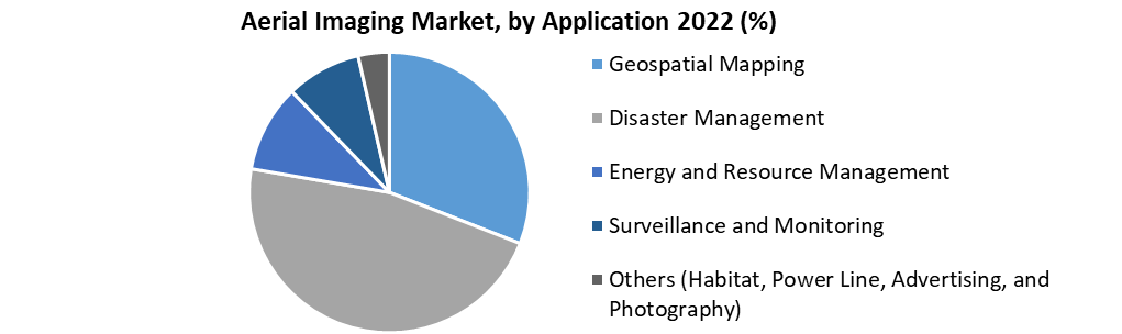 In terms of Platform, Unmanned Aerial Vehicles (UAS) segment shares the fastest growing market during the forecast period. Increasing in UAS production, UAS offer a convenient imaging alternative for capturing aerial photographs in urban areas, government agencies are increase in adaptation of these platforms for law enforcement and crime investigation purposes.