
Drone Data Services Market 2025–2032: AI-Powered Analytics, UAV Mapping Expansion, and Real-Time Aerial Intelligence Driving Industry Transformation
Overview
The Global Drone Data Services Market was valued at USD 2.77 Billion in 2025 and is projected to reach USD 18.82 Billion by 2032, registering a robust CAGR of 31.49% during the forecast period. The market is emerging as one of the fastest-growing segments within the broader digital and geospatial analytics ecosystem, witnessing exponential expansion driven by AI-powered drone analytics, UAV data services, drone mapping services, and real-time aerial data collection technologies. With increasing adoption across industries such as construction, agriculture, oil & gas, mining, infrastructure, and smart cities, the Drone Data Services Market Size is expected to experience significant growth between 2025 and 2032.
The Drone Data Services Market Growth is driven by rising demand for high-precision geospatial data, cost-efficient surveying solutions, and real-time decision-making capabilities. Organizations are rapidly shifting from traditional methods to drone-based photogrammetry, LiDAR drone data services, and AI-powered drone analytics, enhancing efficiency and reducing turnaround time.
The integration of cloud-based drone data processing, edge computing, and 5G-enabled UAV systems is transforming the Drone Analytics Market into a scalable, data-driven ecosystem. As enterprises accelerate digital transformation and automation, the UAV Data Services Market is emerging as a strategic investment opportunity across industries.
Global Drone Data Services Market Overview
The Drone Data Services Market is evolving as a critical enabler of data-driven decision-making, predictive analytics, and operational intelligence. The ability to capture, process, and analyze high-resolution aerial data in real-time has positioned drone services as a core component of enterprise analytics strategies.
The Drone Data Processing Market continues to expand as organizations increasingly rely on AI-powered insights, GIS drone mapping services, and 3D modeling technologies to optimize workflows and reduce operational risks. The shift toward Drone-as-a-Service (DaaS) models is further accelerating adoption by offering subscription-based, scalable, and cost-effective solutions.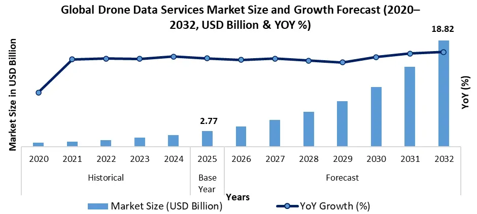
To know about the Research Methodology:-Request Free Sample Report
Drone Data Services Market Key Highlights:
| Market Parameter | Value / Insight | Trend |
| Global Drone Data Services Market Size (2025) | USD 2.77 Billion | ↑ Strong Growth |
| Projected Market Size (2032) | USD 18.82 Billion | ↑ Accelerating Expansion |
| Forecast CAGR (2026–2032) | 31.49% | ↑ High-Growth Industry |
| Dominant Service Type (2025) | Mapping & Surveying | ↑ Market Leader |
| Second Largest Segment | Photogrammetry | ↑ Rapid Adoption |
| Third Largest Segment | 3D Modeling & Digital Elevation Model (DEM) | ↑ Increasing Demand |
| Cloud-Based Drone Data Processing Share (2025) | 55%+ Deployment Share | ↑ Dominant Model |
| AI in Drone Data Services Adoption | Rapid integration in analytics, automation & predictive insights | ↑ Transformational Growth |
| Drone Mapping Services Market | Primary growth driver across construction & infrastructure | ↑ Expanding Adoption |
| Drone-as-a-Service (DaaS) Growth | High adoption due to subscription-based and cost-efficient models | ↑ Scalable Expansion |
| Average ROI Realization | 10–16 Months Implementation Cycle | ↑ Attractive Investment |
| Survey Cost Reduction Potential | 30–50% Savings | ↑ Cost Efficiency |
| Operational Efficiency Improvement | Up to 40% productivity gain | ↑ Performance Boost |
| Fastest Growing Region | Asia Pacific | ↑ Highest CAGR |
| Leading Regional Market (2025) | North America | ↑ Revenue Leader |
Key Market Drivers for the Drone Data Services Market
• AI in Drone Data Services & Predictive Analytics Revolution
The integration of AI-powered drone analytics is transforming how organizations extract value from aerial data. Advanced algorithms process high-resolution imagery, thermal data, and LiDAR outputs to deliver actionable insights in real time.
AI enables:
1. Predictive maintenance in infrastructure
2. Crop health monitoring in precision agriculture
3. Risk assessment in mining and oil & gas operations
This shift is significantly enhancing the Drone Analytics Market Trends and Insights, positioning AI as a primary growth catalyst.
• Rapid Expansion of Drone Mapping Services Market
The Drone Mapping Services Market is witnessing widespread adoption due to its ability to deliver accurate, high-speed, and cost-effective geospatial data. Compared to traditional surveying, drone-based mapping reduces project timelines by up to 60%, making it a preferred solution across industries.
Applications include:
1. Topographic mapping
2. 3D terrain modeling
3. Urban planning and smart city development
• Growth in Commercial Drone Data Services Market
The Commercial Drone Services Market is expanding rapidly as enterprises seek real-time aerial intelligence for operational optimization. Industries such as construction, logistics, and utilities are leveraging drone data for site monitoring, asset inspection, and workflow automation.
• Cloud-Based Drone Data Processing Market
The Cloud-Based Drone Data Analytics Market accounts for the majority of deployments due to its scalability and cost efficiency.
Cloud integration enables:
1. Real-time data processing and visualization
2. Centralized analytics dashboards
3. Remote collaboration across geographies
4. Subscription-based Drone-as-a-Service (DaaS) models
This significantly enhances the Drone Data Services Market Growth Rate.
• Rising Demand for Aerial Data Collection Market Solutions
The Aerial Data Collection Market is gaining traction as organizations require high-frequency, high-accuracy data for decision-making. Drone-based data collection offers unmatched flexibility compared to satellite imaging and manual surveys.
• Integration of IoT, 5G, and Edge Computing
The convergence of IoT-enabled sensors, 5G connectivity, and edge computing is revolutionizing the UAV Data Services Market. Real-time data transmission and processing enable faster insights and improved operational responsiveness.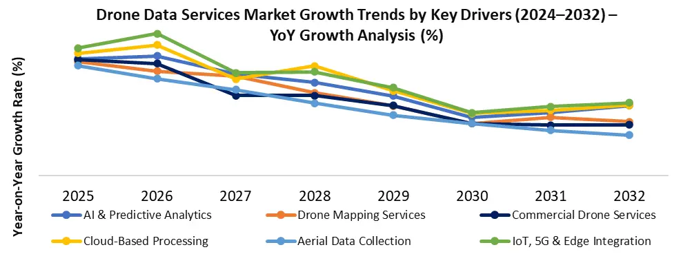
Emerging Trends Shaping the Drone Data Services Industry
• Drone-as-a-Service (DaaS) Market Expansion
The shift toward Drone-as-a-Service (DaaS) is reducing entry barriers for enterprises. Organizations can access advanced drone analytics without heavy capital investment.
• AI and Machine Learning Integration
AI is enabling:
1. Automated image recognition
2. Anomaly detection
3. Real-time analytics dashboards
This is accelerating the evolution of the Drone Data Processing Market.
• Digital Twin & 3D Mapping Technologies
The integration of digital twin models with drone data is transforming industries such as construction and infrastructure by enabling real-time simulation and predictive planning.
• Sustainable and Smart City Applications
Drone data is increasingly used in:
• Urban planning
• Environmental monitoring
• Disaster management
This supports the growth of smart city aerial data solutions.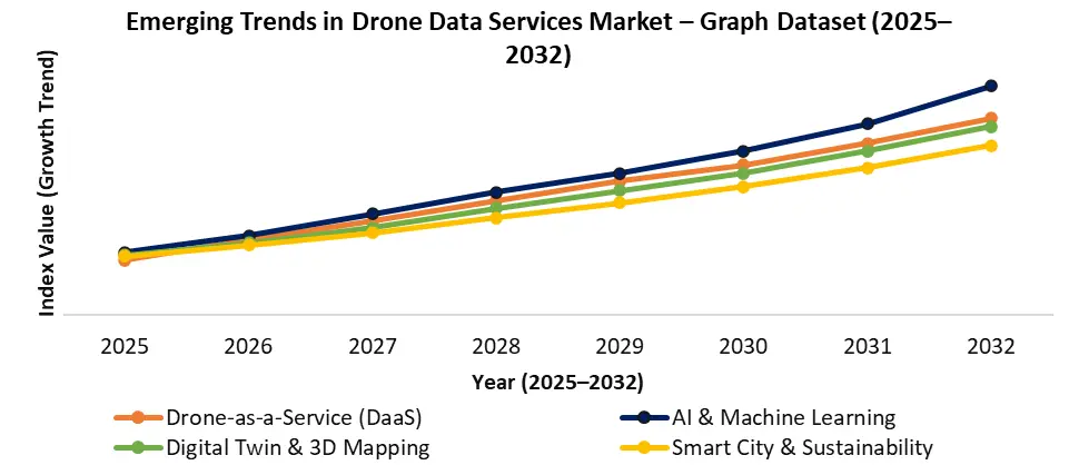
Technology Disruption & Digital Transformation Strategy
Digital transformation is at the core of the Drone Data Services Market Outlook. The convergence of:
• AI-powered drone analytics
• Cloud-based drone data processing
• 5G-enabled UAV systems
• Edge computing architectures
is transforming the market into a real-time intelligence ecosystem.
The Drone Analytics Market is transitioning from basic aerial imaging to advanced data intelligence platforms, offering:
• Predictive modeling
• Real-time dashboards
• Automated reporting
• AI-driven insights
This evolution is shifting the market from data collection to strategic intelligence generation.
Edge AI & Real-Time Drone Analytics Revolution
The integration of Edge AI in Drone Data Services Market is enabling real-time data processing directly on UAV systems, eliminating latency associated with cloud-based workflows. This advancement is transforming mission-critical applications such as infrastructure inspection, disaster response, and defense surveillance, where immediate insights are crucial.
Edge AI enables:
• On-device data processing and instant decision-making
• Reduced bandwidth dependency and faster response times
• Enhanced operational efficiency in remote environments
This trend is significantly strengthening the Drone Analytics Market Trends, shifting the industry toward real-time aerial intelligence and autonomous analytics capabilities.
Integration of Drone Data with Enterprise Digital Platforms (ERP & GIS Ecosystems)
The increasing integration of UAV data services with enterprise systems such as ERP, GIS, and digital asset management platforms is redefining how organizations utilize aerial intelligence. Companies are embedding drone data insights directly into business workflows, enabling seamless decision-making across operations.
This integration supports:
• End-to-end workflow automation in construction and infrastructure projects
• Enhanced geospatial intelligence through GIS-based drone mapping services
• Data-driven asset lifecycle management and predictive maintenance
As a result, the Drone Data Services Market Growth is increasingly driven by its role as a strategic data layer within enterprise digital transformation initiatives, rather than just a standalone data collection tool.
Strategic Cost & ROI Analysis in the Drone Data Services Market
One of the key decision-making factors in the Global Drone Data Services Market is Return on Investment (ROI).
Organizations achieve value through:
• Survey Cost Reduction (30–50%)
• Faster Project Completion (up to 60%)
• Reduced Labor Costs
• Improved Data Accuracy (up to 95%)
The Drone Data Services Market Analysis indicates that most enterprises achieve ROI within 10–16 months, making it a highly attractive investment.
The adoption of AI in the Drone Data Services Market further enhances cost efficiency by reducing manual intervention and improving predictive capabilities.
Drone Data Services Market Segment Analysis
Mapping & Surveying segment dominated the Drone Data Services Market, driven by strong demand for drone mapping services, UAV data services, and aerial data collection across construction, mining, and infrastructure sectors. The Photogrammetry segment ranked second, supported by increasing adoption of AI-powered drone analytics and high-resolution imaging solutions. 3D Modeling & Digital Elevation Model (DEM) emerged as the third-largest segment, gaining traction in digital twin applications and smart city planning, reinforcing overall Drone Analytics Market growth and trends.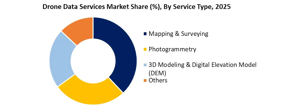
Drone Data Services Market Regional Insights
• North America Drone Data Services Market – Market Leader
North America leads due to advanced digital infrastructure, high adoption of AI technologies, and strong presence of drone analytics companies.
• Europe Drone Data Services Market – Compliance & Sustainability Driven
Europe focuses on environmental monitoring, regulatory compliance, and sustainable infrastructure development, supporting steady growth.
• Asia Pacific Drone Data Services Market – Fastest Growing Region
Countries like India, China, and Southeast Asia are witnessing rapid growth due to smart city initiatives, agricultural modernization, and infrastructure expansion.
• Middle East & Africa – Emerging Opportunities
Investments in oil & gas, mining, and large-scale infrastructure projects are driving adoption of drone data services.
Drone Data Services Market Competitive Landscape
The Global Drone Data Services Market Competitive Landscape is highly dynamic, with key players focusing on AI-driven analytics, cloud platforms, and real-time data processing capabilities.
Leading companies include:
1. DroneDeploy – Leader in cloud-based drone analytics platforms
2. PrecisionHawk – Strong in enterprise drone data services
3. Aerodyne Group – Global provider of drone inspection solutions
4. Skycatch – Specializes in construction data analytics
5. Delair – Focuses on industrial UAV data solutions
These companies are driving innovation in the Drone Analytics Market, enhancing market share, competitive positioning, and technological advancements.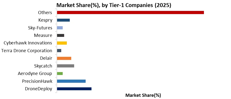
Drone Data Services Market Recent Key Development:
| Date | Company | Development | Impact |
| Jan-25 | DroneDeploy | Launched AI-powered real-time analytics platform | Enhanced automation and analytics capabilities |
| Nov-24 | Aerodyne Group | Expanded operations in Asia Pacific | Strengthened regional market presence |
| Sep-24 | Delair | Introduced advanced LiDAR drone solutions | Improved data accuracy and mapping efficiency |
| Jun-24 | PrecisionHawk | Partnered with infrastructure firms | Accelerated adoption in construction sector |
| Mar-24 | Skycatch | Upgraded cloud analytics platform | Improved scalability and real-time processing |
Drone Data Services Market Scope: Inquire before buying
| Drone Data Services Market | |||
|---|---|---|---|
| Report Coverage | Details | ||
| Base Year: | 2025 | Forecast Period: | 2026-2032 |
| Historical Data: | 2020 to 2025 | Market Size in 2025: | USD 2.77 Bn. |
| Forecast Period 2026 to 2032 CAGR: | 31.49% | Market Size in 2032: | USD 18.82 Bn. |
| Segments Covered: | by Service Type | Mapping & Surveying Photogrammetry 3D Modeling & Digital Elevation Model (DEM) Others |
|
| by Platform | Cloud-Based Operator Software |
||
| by End-Use | Real Estate & Construction Agriculture Mining Oil & Gas Renewables Others |
||
North America (United States, Canada, and Mexico)
Europe (UK, France, Germany, Italy, Spain, Sweden, Austria, and, Rest of Europe)
Asia Pacific (China, South Korea, Japan, India, Australia, Indonesia, Malaysia, Vietnam, Taiwan, Bangladesh, Pakistan, and, Rest of APAC)
Middle East and Africa (South Africa, GCC, Egypt, Nigeria, and, Rest of ME&A)
South America (Brazil, Argentina, and, Rest of South America)
Key Players/Competitors Profiles Covered in the Drone Data Services Market Report in Strategic Perspective
Tier 1 – Market Leaders (Core Drone Data & Analytics Players)
1. DroneDeploy
2. PrecisionHawk
3. Aerodyne Group
4. Skycatch
5. Delair
6. Terra Drone Corporation
7. Cyberhawk Innovations
8. Measure
9. Sky-Futures
10. Kespry
Tier 2 – Enterprise & Industrial Drone Service Providers
11. Quantum Systems
12. Wingtra
13. senseFly
14. Parrot SA
15. DJI
16. ideaForge Technology
17. Garuda Aerospace
18. Asteria Aerospace
19. Flytrex
20. Zipline
21. 4DMapper
Tier 3 – Geospatial, Mapping & Analytics Specialists
22. Pix4D
23. Propeller Aero
24. AgEagle Aerial Systems
25. Sentera
26. DroneMapper
27. SimActive
28. Airware Limited
29. HawkEye 360
30. Nearmap
31. EagleView
32. Agribotix
Tier 4 – Inspection, Energy & Industrial Focused Players
33. Skydio
34. Percepto
35. Volatus Aerospace
36. Heliguy
37. ABJ Drones
38. DroneBase
39. Identified Technologies
40. UAVIA
41. Flyability
42. Inspector Systems
Tier 5 – Emerging & Niche Technology Players
43. Teal Drones
44. Draganfly
45. Delair AI
46. FlyGuys
47. Airobotics
48. Altitude Angel
49. Unifly
50. AirMap
51. Skyward
52. Kespry Analytics