
3D Terrestrial Laser Scanning Market Size by Type, Application, End User, Region, Industry-Wide Analysis, Competitive Landscape Assessment & Long-Term Forecast to 2034
Overview
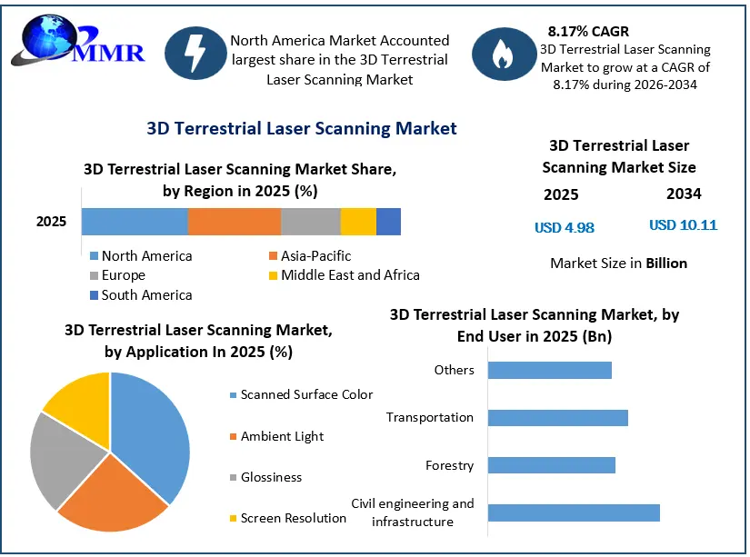
Global 3D Terrestrial Laser Scanning Market is expected to reach USD 10.11 Bn. by 2034, at a CAGR of 8.17% during the forecast period.
3D terrestrial laser scanners are used for detailed 3-dimensional data acquisition of objects. It is a superior way, which producesthe 3D models speedily.
3D Terrestrial Laser Scanning Market Dynamics:
In current years, the measurement systems and techniques have become popularin the market for three-dimensional (3D) surveying of objects. The demand for 3D terrestrial laser scanning is expected to grow at a rapid rate because of high requirement of 3D-data, andfast area-wide 3D-measurement methods. 3D terrestrial laser scanners haveestablishedas ameasurement method for fast, area-wide 3D-surveying in the field of surveying and the field of engineering geodesy.
3D Terrestrial Laser Scanning Market Growth and Share Analysis
To Know About The Research Methodology :- Request Free Sample Report
Technology advancement 3D laser scanning hardware and software technologies, integration of best-practice work processes by practitioners and different distribution channel strategy by prominent key players are some of the prominent driving factors behind the global 3D terrestrial laser scanning market growth. For instance, Leica Geosystems has introduced the360 mobile-device app for 3D terrestrial laser scanners. The report covers a detailed analysis of the global 3D terrestrial laser scanning market dynamics like drivers, restraints, opportunities and challenges by each region. The report study has also analyzed revenue impact of the COVID-19 pandemic on the sales revenue of the market leader, market followers and market disrupters in the report and same is reflected in our analysis.
3D Terrestrial Laser Scanning Market Segment Analysis:
The report covers the detailed analysis of the global 3D terrestrial laser scanning market with the classifications of the market on the basis of type, application, end user and region. Analysis of past market dynamics from 2020 to 2025 is given in the report, which will help readers to benchmark the past trends with current market scenarios with the key player's contribution in it.
The number of construction sites are adopting 3D terrestrial laser scanning technology.It reduces the high costs of operation. Many organizations are expected to adopt 3D terrestrial laser scanning technology to reduce risk, speed up task completion and deliver improved quality control. The rapid expansion of the civil engineering and infrastructure across the globe is expected to drive the global market growth. Furthermore, 3D terrestrial laser scanning alsohelps in tracking the transportation system. It assist the organizations in maintaining the record of transport facilities. It is used in railways and roadways to maintain the supply of goods.
3D Terrestrial Laser Scanning Market Regional Analysis:
North America held xx% share in 2025 and projected to contribute xx% share during the forecast period. An increase in adoption of innovative technology and awareness about the financial expenses among organizations are some of the factors that drives the regional market growth. Also, investment in the printing techniques and scanning methods are expected to increase the adoption of the 3D terrestrial laser scanning method. Presence of the prominent players and their business strategy, end user distribution platform through app are expected to drive the market growth.
On the other hand, Asia Pacific region is expected to grow at a xx% rate of CAGR during the forecast period. 3D terrestrial scanners are expected to adopt widely across developing economies due to decreased power consumption, size, weight and price and high Civil engineering and infrastructure activities. The manufacturing and application environment in each region is different and focus is given on the regional impact on the cost of manufacturing, supply chain, availability of raw materials, labor cost, availability of advanced technology, trusted vendors in the report.
3D Terrestrial Laser Scanning Market Competitive Analysis:
Many organizations are increasingly adopting laser scanning technology as the 3D terrestrial laser scanners perform and complete the task in a given time frame. Some of the prominent key players are focusing to deploy 3D terrestrial laser scanners and organizations from the countries India, China and Japan are utilizing the opportunities and implementing successful integration of laser scanners in the end user industries. The report has profiled fourteen key players in the market from different regions. However, the report has considered all market leaders, followers, and new entrants with investors while analyzing the market and estimating the size of the same.
The objective of the report is to present a comprehensive analysis of the Global marketincluding all the stakeholders of the industry. The past and current status of the industry with forecasted market size and trends are presented in the report with the analysis of complicated data in simple language.
The report covers all the aspects of the industry with a dedicated study of key players that includes market leaders, followers and new entrants by region. PORTER, SVOR, PESTEL analysis with the potential impact of micro-economic factors by region on the market has been presented in the report. External as well as internal factors that are supposed to affect the business positively or negatively have been analyzed, which will give a clear futuristic view of the industry to the decision-makers.
The report also helps in understanding the Global market dynamics, structure by analyzing the market segments and projects the Global market size. Clear representation of competitive analysis of key players by Application, price, financial position, Product portfolio, growth strategies, and regional presence in the Global market make the report investor’s guide.
3D Terrestrial Laser Scanning Market Recent Industry Developments
| Date | Company | Development | Impact |
|---|---|---|---|
| 07 October 2025 | Topcon Positioning Systems | Topcon launched its next-generation CR-P1 multi-functional 3D terrestrial laser scanner alongside the Collage Cloud Connector platform at INTERGEO 2025. | The system provides real-time, georeferenced point cloud generation on-site to drastically accelerate BIM and infrastructure workflows. |
| 13 January 2025 | RIEGL Laser Measurement Systems | RIEGL showcased the commercial deployment of its VZ-600i high-performance 3D terrestrial laser scanner tailored specifically for AEC and BIM applications at the BAU 2025 exposition. | The scanner enables over 60 scan positions per hour with automatic real-time registration and a measuring range of up to 1,000 meters. |
| 20 October 2025 | Leica Geosystems | Leica Geosystems introduced updated AI-driven software integration for its terrestrial laser scanning portfolio across North American infrastructure markets. | The enhanced feature extraction software significantly reduces manual data processing times for complex digital twin modeling. |
| 06 August 2026 | FARO Technologies, Inc. | FARO expanded its terrestrial solution line with new Traceable 3D target-based accessories designed for the FARO Focus laser scanner suite. | The release guarantees a 1mm system accuracy calibration across repeating industrial geometries and large-scale outdoor site surveys. |
3D Terrestrial Laser Scanning Market Scope: Inquire before buying
| 3D Terrestrial Laser Scanning Market | |||
|---|---|---|---|
| Report Coverage | Details | ||
| Base Year: | 2025 | Forecast Period: | 2026-2034 |
| Historical Data: | 2020 to 2025 | Market Size in 2025: | USD 4.98 Bn. |
| Forecast Period 2026 to 2034 CAGR: | 8.17% | Market Size in 2034: | USD 10.11 Bn. |
| Segments Covered: | by Type | Spatial Cloud Data Digital Elevation Model (DEM) Digital Terrain Model (DTM) Contour Maps |
|
| by Application | Scanned Surface Color Ambient Light Glossiness Screen Resolution |
||
| by End User | Civil engineering and infrastructure Forestry Transportation Others |
||
3D Terrestrial Laser Scanning Market, by Region
North America (United States, Canada and Mexico)
Europe (UK, France, Germany, Italy, Spain, Sweden, Austria and Rest of Europe)
Asia Pacific (China, South Korea, Japan, India, Australia, Indonesia, Malaysia, Vietnam, Taiwan, Bangladesh, Pakistan and Rest of APAC)
Middle East and Africa (South Africa, GCC, Egypt, Nigeria and Rest of ME&A)
South America (Brazil, Argentina Rest of South America)
3D Terrestrial Laser Scanning Market, Key Players
1. Leica Geosystems (Hexagon AB)
2. Teledyne Optech (Teledyne Technologies)
3. Trimble Inc.
4. Zoller + Fröhlich GmbH
5. FARO Technologies, Inc.
6. GeoDigital
7. Maptek Pty Ltd
8. Measurement Devices Ltd (MDL)
9. Optech Incorporated
10. RIEGL Laser Measurement Systems GmbH
11. Spatial Integrated Systems, Inc.
12. Topcon Positioning Systems
13. Beijing Hi-Target Surveying Instrument Co., Ltd.
14. GeoSLAM Ltd (3D Robotics / FARO)
15. Stonex S.r.l.
16. Carl Zeiss AG
17. Artec 3D
18. Perceptron, Inc.
19. Creation 3D / 3D Digital Corp
20. CREAFORM (AMETEK Inc.)
21. Autodesk, Inc.
22. Bentley Systems, Incorporated
23. Mapix Technologies Ltd
24. Nikon Metrology NV
25. PENTAX Industrial
26. Clauss Spezielle Messgeräte GmbH
27. Merrett Survey Ltd
28. Surphaser (Basement Light Inc.)
29. Regental Laser Scanner Technik
30. Kubit GmbH
Frequently Asked Questions:
1. Which region has the largest share in Global 3D Terrestrial Laser Scanning Market?
Ans: North America region held the highest share in 2025.
2. What is the growth rate of Global 3D Terrestrial Laser Scanning Market?
Ans: The Global 3D Terrestrial Laser Scanning Market is growing at a CAGR of 8.17% during forecasting period 2026-2034.
3. What is scope of the Global 3D Terrestrial Laser Scanning Market report?
Ans: Global 3D Terrestrial Laser Scanning Market report helps with the PESTEL, PORTER, COVID-19 Impact analysis, Recommendations for Investors & Leaders, and market estimation of the forecast period.
4. Who are the key players in Global 3D Terrestrial Laser Scanning Market?
Ans: The important key players in the Global 3D Terrestrial Laser Scanning Market are – Leica Geosystems, Teledyne Optech, Trimble Navigation, Zollar + Frohlich, Faro Technologies, GeoDigital, Maptek, Measurement devices, Optech, RIEGL Laser, Spatial Integrated Systems, Others, and
5. What is the study period of this Market?
Ans: The Global 3D Terrestrial Laser Scanning Market is studied from 2020 to 2034.