
Surface and Field Analytics Market – Global Market Size, Strategic Growth Drivers, Risk Assessment Framework, Regulatory Landscape Review, Competitive Intensity Mapping & Long-Term Industry Outlook to 2029
Overview
Surface and Field Analytics Market was valued at USD 23.41 Billion in 2022 and is expected to reach USD 43.90 Billion by 2029, exhibiting a CAGR of 9.4 % during the forecast period (2023-2029)
The Surface and Field Analytics market is witnessing massive growth in recent times as there are a rise in the use of artificial intelligence (AI), machine learning (ML), and cloud computing bases GIS solutions in geospatial analytics. As there is a tsunami of data being consumed by organizations, the complexity, and capabilities to handle the vast amount of data will rise. AI and ML are making these large data handling easy and quick from different sources such as satellites, aerial vehicles, and ground technologies. Additionally, the rise of urbanization and government projects are constituting the rapid integration of AI and ML. Also, through automation, AI can extract information and provide real-time insights from spatial big data.
Geospatial analytics has applications across various domains such as agriculture, military, telecommunications, weather monitoring, maritime surveillance, urban planning/development, oil/gas, energy, natural resource exploration, aviation, healthcare, surveying/cartography, disaster management, business intelligence, finance/insurance, and mining. Hence, the capability to serve diverse industries, enhance operations, and have data-driven decision-making, has led to the large-scale adoption of geospatial analytics, which further increases the demand for Surface and Field Analytics. Some of the major key players providing Surface and Field Analytics solutions are Bruker Corporation, Carl Zeiss AG, Danaher Corporation, JOEL Limited, Nikon Corporation, Olympus Corporation, Shimadzu Corporation, and Thermo Fisher Scientific, Inc.
The future of geospatial technologies is promising with many innovative methods and technologies. These new technologies enable meaningful insights and forecast the future. For instance, geospatial technologies have played a significant role in major climate events or battling the recent COVID-19 pandemic. Additionally, the Surface and Field Analytics industry is witnessing the demand for accurate, real-time, precise, and insightful geospatial data for futuristic technologies such as digital twins and metaverse environments. The digital twin is already trending in the Surface and Field Analytics market, but the technology has much more to provide on a broad scale. Furthermore, companies are developing advanced software solutions to help create accurate, real-time, and scalable formation digital twins.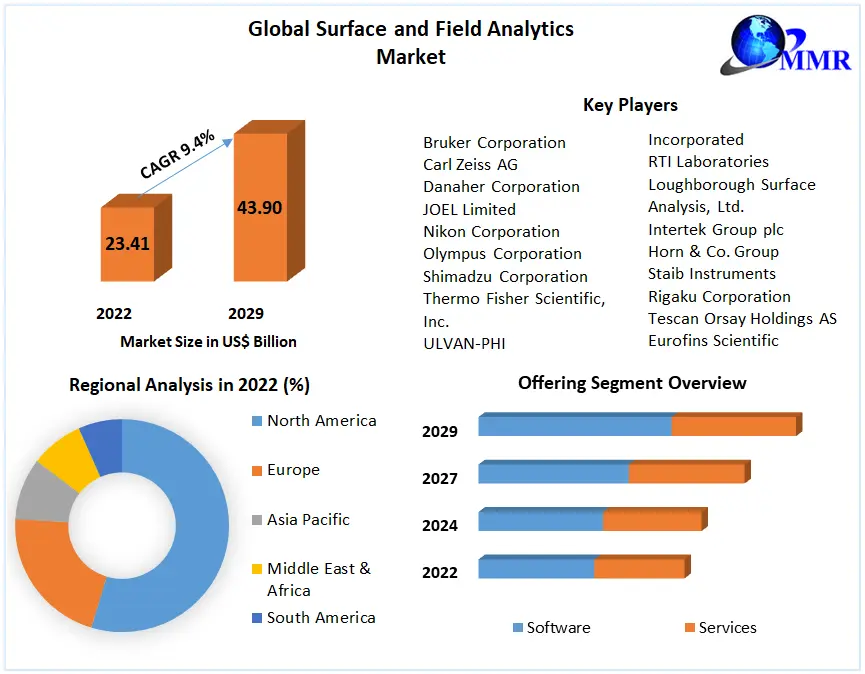 To know about the Research Methodology :- Request Free Sample Report
Current Technological Trends in the Surface and Field Analytics Market
Imaging Capabilities: Synthetic aperture radar (SAR) imagery is experiencing growth because of the evolution of integrated domain awareness solutions integrating multiple data sets. Satellite imaging companies are increasing their SAR imagery portfolio for private and government applications. The companies are also providing SAR imagery to Ukraine for national defense. Many other SAR companies are focusing on the public sector, providing solutions for applications such as infrastructure, agriculture, finance, and energy. Furthermore, a Japanese space start-up, Synspective, is developing 24-hour SAR satellite imagery services to provide central and regional governments with a way to combat natural calamities and asses the damages. The company has planned to have a constellation of 30 SAR satellites placed in low Earth orbit by 2026. The Earth imagery taken from aerial methods (aircraft/drones) is also gaining popularity due to their high-resolution optical imagery taken from a low altitude as compared to the satellites. Furthermore, SAR technology is now not limited to satellites. This trend is expected to drive the growth of the Surface and Field Analytics market.
Artificial Intelligence (AI)/Machine Learning (ML): Artificial intelligence (AI) is used extensively in geospatial imagery analytics and quickly performs the most challenging and critical tasks with accuracy. Machine learning is the subpart of artificial intelligence with which it is possible. Furthermore, geospatial artificial intelligence (GeoAI) combines spatial analytics with artificial intelligence to understand and analyze geospatial data. The GeoAI is integral to autonomous transportation, smart cities, the military, and other applications. Additionally, it is classified into two segments, namely, geospatial machine learning and geospatial deep learning. Geospatial machine learning deals with tasks such as geographical clustering, spatial classification, and regression. In contrast, geospatial deep learning performs duties such as 3D analysis and imagery analysis. The increase of AI and ML in Surface and Field Analytics is expected to drive the Surface and Field Analytics market growth.
3D Modeling/Digital Twin: One of the most rising uses of geographic information systems (GIS) is 3D modeling/digital twin. The digital twin is generally a 3D representation of an object such as a jet turbine, building, or whole city. It is used to analyze, optimize operational efficiencies, enhance decision-making, and predict real-world performance with the help of AI. GIS data is being used extensively in creating the geospatial digital twins of buildings. It contains quantifiable data about the building, such as the number of floors and the year built. Furthermore, it is also used for integrations with the help of digital GIS data representation. Hence, geospatial digital twin’ technology helps gain more insights about the building with more GIS data, emergency planning, risk management, and others. Thus, digital twins help make informed decisions for the building/cities and operations. 3D Modeling and Digital Twin are expected to boost the growth of the Surface and Field Analytics market.
LiDAR Technology: Light detection and ranging (LiDAR) is a technology based on optical remote sensing. LiDAR technology was introduced in the 1960s and installed in airplanes, but it got recognition when GPS was introduced to calculate geospatial information in the 1980s. Now LiDAR technology is popular in integrating GIS databases with many software platforms, such as ENVI and ArcGIS providing robust LiDAR analysis features. Currently, LiDAR mapping is widespread and used in various domains worldwide. The government and organizations use aerial methods, also known as airborne LiDAR, equipped with drones, helicopters, and airplanes. The increased use of trending LiDAR technology in the Surface and Field Analytics market is expected to drive the growth of the Surface and Field Analytics industry.
Small Satellites: Conventionally, the geospatial service provider scientists go to the government website for free or paid high-resolution satellite imagery data or buy it from private companies. The satellite imagery prices go up with the higher resolution images. Both government and private companies would get high-resolution images from larger satellites orbiting around the Earth. However, currently, small satellite deployment is growing, and many start-ups are entering the market to provide cost-effective satellite imagery data. The companies provide synthetic aperture radar (SAR) imagery through its SAR constellation for customers of diverse sectors such as maritime monitoring, insurance and finance, security, and disaster management. The SAR data can be collected at any time of the day and is not affected by the cloudy cover.
Furthermore, many companies are developing and deploying micro nanosatellites that can provide geospatial and imagery data. These satellites contain miniaturized sensors compatible with small satellites that can produce high-resolution imagery at affordable prices, which enables geospatial service providers to cater to customers on a small budget. The above-mentioned factors are estimated to increase the usage of small satellites in the Surface and Field Analytics market, which is further expected to boost the Surface and Field Analytics industry growth during the forecast period.
Surface and Field Analytics Market Drivers and Opportunities
Increasing Need for Data-Driven Decision Making: Geospatial data analysis requires the collection, combination, and visualization of geospatial data. The data dependence is only growing as companies are evolving more precise and accurate analytics. With data-driven analytics, companies can achieve warnings of the changes which they can bring in the future event and increase the efficiency of their offerings. For example, the agriculture industry uses a large amount of near-real-time for monitoring the land/crops. This process includes the flow of a large amount of data for more accurate and precise data-driven analytics. The demand for data is driving the geospatial solution providers. This is expected to drive the growth of the Surface and Field Analytics market.
Increasing Threat Perception Related to Natural Disasters (Impact of Climate Change): Speed and effectiveness is more important than ever when unprecedented catastrophes become more frequent. Local governments, organizations, and emergency management personnel must process and communicate a vast amount of information internally and externally. This information includes population and staff locations, weather events, property exposure, evacuation resources, public safety services, supply chain disruptions, and many more. Using geospatial capabilities can enhance the proactiveness and accurate decision-making of the government and emergency services. Geospatial technologies provide spatial awareness and real-time monitoring. This is expected to drive the Surface and Field Analytics market growth during the forecast period.
Cheaper Geospatial Solutions for Small and Medium Enterprises: With small-satellite constellations and drone operations delivering cheaper imagery products, the Surface and Field Analytics market is now capable of developing cheaper solutions for customers who otherwise cannot afford enterprise-grade solutions utilizing expensive satellite imagery products. This availability of cheaper imagery products could be leveraged by geospatial startups to develop customized new solutions for new end-user groups. The new solutions can add to the existing portfolio, and the service providers' customer base will also grow with the entry of new customers (small and medium enterprises).
Agriculture Sector Tackling Climate Change: The agriculture sector is experiencing a significant climate change impact, and the climate's uncertainty has affected the crops' growth. The agriculture domain stakeholders are implementing various new methods of farming practices to overcome the effect of climate change. For example, climate-smart agriculture (CSA), an integrated approach to enhance agriculture systems and climate-resilient practices, is implemented by agriculture stakeholders for specific climate change impacts faced by them. This is expected to create lucrative opportunities in the Surface and Field Analytics market during the forecast period.
Increasing Role of Geospatial Data in Disaster Management: The role of geospatial data in emergency/disaster management is to focus on planning, analyzing, and action. The biggest challenge for emergency management authorities is to quickly bring back the communities to normalcy. The spatial data is needed for real-time updates of the affected location through collecting data from various sources. Given the state of diversity in natural disasters and their associated sense of urgency, the geospatial solutions catering to such use cases will require diverse data sets. This is estimated to create growth opportunities in the Surface and Field Analytics market.
Surface and Field Analytics Market Restraints and Challenges
Presence of Legacy Systems Delaying Integration with Next-Gen Solutions: The majority of GIS software now available is intended for expert users, and it lacks adequate resource integration for effective computing. They are challenging for other users with a limited geospatial programming background. So, the next-gen solutions should be easier to use and more accurate in performing various tasks. So, for complex next-gen geographic analysis, high-performance computing infrastructures should be used by current GIS analytical functions. Furthermore, businesses might use geospatial data to measure several occurrences of an element or variable to make judgments based on facts. However, a single dataset can only provide a finite amount of geospatial data and be used for finite problems. An organization's operations must integrate and link various datasets to obtain more insights and provide more answers. This is expected to hamper the growth of the Surface and Field Analytics market.
Lack of Mutual Sharing of Data Across Regional Stakeholders: The lack of sharing geospatial data across the various stakeholders results in not utilizing the full capabilities of geospatial technologies. For instance, in the maritime domain, if there is an illegal activity or natural calamity, such as an underwater earthquake spotted on the ocean within a territory of a country, then not sharing the data with neighboring countries would keep them in the dark. If there is data sharing across other stakeholders (countries), then they would be prepared in advance and plan their safety and security operations accordingly. If all the countries share their maritime surveillance data, then it will be a shared domain-level awareness, and it is critical for each stakeholder. This is estimated to restrain the Surface and Field Analytics market growth during the forecast period.
Surface and Field Analytics Market Segment Analysis
Based on the Solution, the analytics segment is expected to dominate the Surface and Field Analytics market during the forecast period. In the Surface and Field Analytics process, the different algorithms integrate the various data and deliver actionable insights. For example, Surface and Field Analytics collects data from satellites. Furthermore, structured data is extracted from high-resolution satellite imagery with the help of AI and ML-based software tools for specific applications. AI and ML can also help spot complex relationships and trends in the data and deliver predictive analysis. Furthermore, there are companies such as Orbital Insight, which provides an AI-powered software platform. The Orbital Insight Platform can provide analytics from multiple geospatial data sources such as satellite images, aerial images, location data, automatic identification system (AIS) data, and more. Additionally, EOS Data Analytics, a cloud-based solution company, provides an EOSDA platform for crop monitoring, land viewing, and forest monitoring. The platform analyses satellite imagery and delivers actionable insights powered by deep learning algorithms.
Based on the Application, the natural resources segment is expected to grow at a significant growth rate during the forecast period. The rise in the human population has increased the dependence on natural resources. Hence, GIS and remote sensing technologies are being used to manage these scarce resources in real-time, efficient, and effective ways. These geospatial technologies also help policymakers to make accurate and data-driven decisions for sustainable growth. Geospatial technologies store, analyze, and visualize spatial data and are capable of change detection in the environment that can affect natural resources. With the help of change detection, specific areas can be identified that require prior attention and necessary action for protection.
The energy sector is one of the volatile sectors where resources distributed are challenging to manage, along with projects often delayed or blocked. The global energy sector uses high-frequency satellite imagery and advanced geospatial analytics to gather information related to change detection in the industry to address the problems. Furthermore, aerial technologies are being extensively used for monitoring purposes in the energy sector.
Geospatial technologies are playing a key role in enhancing and strengthening defense & security. Geospatial technologies deployed in the military offer capabilities such as surveillance, reconnaissance, monitoring, predicting and countering threats, assisting in strategizing and supporting field operations, and providing detailed analysis of any changes in a potential war zone. Additionally, the real-time data and precise situational awareness provided by geospatial technologies help in mitigating risks and secure decision-making. Also, the defense organizations of many countries are implementing more digitization in their processes. Furthermore, during real-time and post-combat operations, a constant flow of information between intelligence and law enforcement agencies is made possible by adopting big data, cutting-edge geospatial analytics software, and advanced imaging technologies from high-resolution remote sensing satellites, UAVs, and other sensors.
Surface and Field Analytics Market Regional Insights
North America region comprises the regional markets of the U.S. and Canada. The global Surface and Field Analytics Market is dominated by the North America region, with huge investments and revenue expected to be generated from the U.S. and Canada markets. Currently, the U.S. is the dominant country that manufactures satellites and provides data imagery and value-added services in North America, and it is expected to remain dominant till 2029. However, Canada is investing heavily in the research and development of Earth observation SAR satellites for various applications and is expected to gain prominence in the Surface and Field Analytics Market during the forecast period. However, the North America region is becoming highly competitive. The huge competition between domestic players and foreign companies expanding their operations in the region has resulted in increased competition in terms of contracts, pricing, funds, and suppliers.
The Europe region countries are highly focused on Surface and Field Analytics solutions and carrying out developments for achieving enhanced imagery for Earth observation, defense and security, and utilities. The region is quickly advancing, and organizations are integrating technologies such as artificial intelligence (AI), machine learning (ML), sensors, and IT development. Hence, the growth of the Surface and Field Analytics industry in the region is augmented. Also, the deployment of small satellites in large numbers in the region helps in cutting down the cost of data acquisition as the small satellites provide less expensive data than larger satellites. Hence, data acquisition in the region has witnessed growth due to easy and cost-effective data availability.
Global Surface and Field Analytics Market Scope: Inquiry Before Buying
| Surface and Field Analytics Market | |||
|---|---|---|---|
| Report Coverage | Details | ||
| Base Year: | 2022 | Forecast Period: | 2023-2029 |
| Historical Data: | 2017 to 2022 | Market Size in 2022: | US 23.41 Bn. |
| Forecast Period 2023 to 2029 CAGR: | 9.4 % | Market Size in 2029: | US 43.90 Bn. |
| Segments Covered: | by Offering | 1.Software 2.Services |
|
| by Deployment Model | 1.On-premise 2.Cloud |
||
| by Solution | 1.Data Acquisition 2. Data Processing 3.Analytics 4.Integrated Delivery Platform |
||
| by Application | 1.Automotive and Transportation 2.Energy and Utilities 3.Government 4.Defense and Intelligence 5.Smart Cities 6.Insurance 7.Natural Resources 8.Others |
||
| by Enterprise Size | 1.Large Enterprises 2.SMEs |
||
| by Region | 1.North America 2.Europe 3.Asia Pacific 4.South America 5.Middle East & Africa |
||
Surface and Field Analytics Market, by Region
North America (United States, Canada and Mexico)
Europe (UK, France, Germany, Italy, Spain, Sweden, Austria and Rest of Europe)
Asia Pacific (China, South Korea, Japan, India, Australia, Indonesia, Malaysia, Vietnam, Taiwan, Bangladesh, Pakistan and Rest of APAC)
Middle East and Africa (South Africa, GCC, Egypt, Nigeria and Rest of ME&A)
South America (Brazil, Argentina Rest of South America)
Surface and Field Analytics Market, Key Players are:
1.Bruker Corporation
2. Carl Zeiss AG
3. Danaher Corporation
4. JOEL Limited
5.Nikon Corporation
6.Olympus Corporation
7. Shimadzu Corporation
8.Thermo Fisher Scientific, Inc.
9.ULVAN-PHI
10. Waters Corporation
11. FEI Company
12. HORIBA, Ltd.
13.Incorporated
14. RTI Laboratories
15. Loughborough Surface Analysis, Ltd.
16.Intertek Group plc
17.Horn & Co. Group
18.Staib Instruments
20. Rigaku Corporation
21.Tescan Orsay Holdings AS
22. Eurofins Scientific
23.The McCrone Group
24.SPECS GmbH
Frequently Asked Questions:
1] What is the growth rate of the Global Surface and Field Analytics Market?
Ans. The Global Surface and Field Analytics Market is growing at a significant rate of 9.4% during the forecast period.
2] Which region is expected to dominate the Global Surface and Field Analytics Market?
Ans. The North America region is expected to dominate the Surface and Field Analytics Market during the forecast period.
3] What is the market size of the Global Surface and Field Analytics Market by 2029?
Ans. The market size of the Surface and Field Analytics Market by 2029 is expected to reach USD 43.90 Bn.
4] What are the major key players of the Global Surface and Field Analytics Market?
Ans. The major key players of the Global Surface and Field Analytics Market are Bruker Corporation, Carl Zeiss AG, Danaher Corporation, JOEL Limited, Nikon Corporation, Olympus Corporation, Shimadzu Corporation, Thermo Fisher Scientific, Inc., and ULVAN-PHI.
5] What factors are driving the growth of the Global Surface and Field Analytics Market in 2022?
Ans. Increasing need for data-driven decision making and increasing threat perception related to natural disasters are the major factors expected to drive the Global Surface and Field Analytics Market during the forecast period.